IMAGES TAKEN NEAR TO
Alcester Road, WORCESTER, WR7 4LS
Introduction
This page details the photographs taken nearby to Alcester Road, WR7 4LS by members of the Geograph project.
The Geograph project started in 2005 with the aim of publishing, organising and preserving representative images for every square kilometre of Great Britain, Ireland and the Isle of Man.

There are currently over 7.5m images from over14,400 individuals and you can help contribute to the project by visiting https://www.geograph.org.uk
Image Map
Images are licensed for reuse under creativecommons.org/licenses/by-sa/2.0
Notes
- Clicking on the map will re-center to the selected point.
- The higher the marker number, the further away the image location is from the centre of the postcode.
Image Listing (5 Images Found)
Images are licensed for reuse under creativecommons.org/licenses/by-sa/2.0
Image
Details
Distance
1
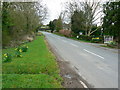
The road to Radford, Worcestershire
Radford lies ahead out of sight round the bend in this view of the road facing west.
Image: © Brian Robert Marshall
Taken: 3 Apr 2008
0.01 miles
2
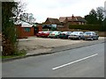
Dudleys Coaches, east of Radford
A small office and depot for a coach company occupy a site just north of the road to Radford.
Image: © Brian Robert Marshall
Taken: 3 Apr 2008
0.07 miles
3
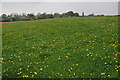
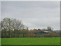
Farmland at Radford
This grid square is predominantly farmland with footpaths crossing it.
Image: © Philip Halling
Taken: 29 Apr 2011
0.15 miles