IMAGES TAKEN NEAR TO
Poplar Piece, WORCESTER, WR7 4JD
Introduction
This page details the photographs taken nearby to Poplar Piece, WR7 4JD by members of the Geograph project.
The Geograph project started in 2005 with the aim of publishing, organising and preserving representative images for every square kilometre of Great Britain, Ireland and the Isle of Man.

There are currently over 7.5m images from over14,400 individuals and you can help contribute to the project by visiting https://www.geograph.org.uk
Image Map
Images are licensed for reuse under creativecommons.org/licenses/by-sa/2.0
Notes
- Clicking on the map will re-center to the selected point.
- The higher the marker number, the further away the image location is from the centre of the postcode.
Image Listing (17 Images Found)
Images are licensed for reuse under creativecommons.org/licenses/by-sa/2.0
Image
Details
Distance
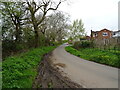
1
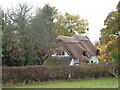
Thatched Cottage on Appletree Lane, Inkberrow
Image: © Jeff Gogarty
Taken: 11 Nov 2017
0.06 miles
2
Interesting garden furniture
At a house on Appletree Lane, Inkberrow
Image: © Jeff Gogarty
Taken: 11 Nov 2017
0.07 miles
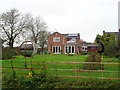
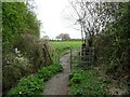
3
Stream and footpath through the back garden
Some houses in Inkberrow have been extended to include a stream and a public right of way. There are stiles on either side of the garden to allow walkers to pass.
Image: © Jeff Gogarty
Taken: 11 Nov 2017
0.07 miles
5
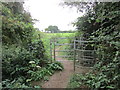
Footpath gate on Appletree Lane
The footpath leads to Goom's Hill.
Image: © Jonathan Thacker
Taken: 11 Sep 2018
0.08 miles
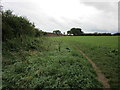
7
Footpath to Goomshill Farm
Off Appletree Lane.
Image: © JThomas
Taken: 16 Apr 2023
0.09 miles
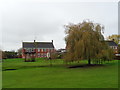
8
Path and modern houses, Inkberrow
A footpath runs across the house gardens.
Image: © Jeff Gogarty
Taken: 11 Nov 2017
0.11 miles
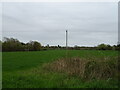
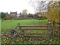
10
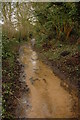
Bridleway at Inkberrow
This bridleway to the north of Appletree Lane, Inkberrow appears more like a stream then a public right of way.
Image: © Philip Halling
Taken: 31 Dec 2009
0.13 miles