IMAGES TAKEN NEAR TO
Stockton, WORCESTER, WR6 6XG
Introduction
This page details the photographs taken nearby to WR6 6XG by members of the Geograph project.
The Geograph project started in 2005 with the aim of publishing, organising and preserving representative images for every square kilometre of Great Britain, Ireland and the Isle of Man.

There are currently over 7.5m images from over14,400 individuals and you can help contribute to the project by visiting https://www.geograph.org.uk
Image Map
Images are licensed for reuse under creativecommons.org/licenses/by-sa/2.0
Notes
- Clicking on the map will re-center to the selected point.
- The higher the marker number, the further away the image location is from the centre of the postcode.
Image Listing (4 Images Found)
Images are licensed for reuse under creativecommons.org/licenses/by-sa/2.0
Image
Details
Distance
1
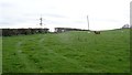
Ewes and lambs, Stockton
Worcestershire pasture with the powerline to Tenbury and Ludlow in the background. Stourport power station used to be on the other end.
Image: © Richard Webb
Taken: 31 Mar 2019
0.14 miles
2

Newly Mown Verge On The Lane To Worles Common
Image: © Peter Whatley
Taken: 15 Sep 2009
0.20 miles
3

Clenchall Cottages
The view south from these houses on the ridge above Stockton on Teme must be outstanding.
Image: © Peter Whatley
Taken: 15 Sep 2009
0.21 miles
