IMAGES TAKEN NEAR TO
Pudford Lane, WORCESTER, WR6 6QL
Introduction
This page details the photographs taken nearby to Pudford Lane, WR6 6QL by members of the Geograph project.
The Geograph project started in 2005 with the aim of publishing, organising and preserving representative images for every square kilometre of Great Britain, Ireland and the Isle of Man.

There are currently over 7.5m images from over14,400 individuals and you can help contribute to the project by visiting https://www.geograph.org.uk
Image Map
Images are licensed for reuse under creativecommons.org/licenses/by-sa/2.0
Notes
- Clicking on the map will re-center to the selected point.
- The higher the marker number, the further away the image location is from the centre of the postcode.
Image Listing (7 Images Found)
Images are licensed for reuse under creativecommons.org/licenses/by-sa/2.0
Image
Details
Distance
1
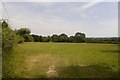
Field, Hill Side
Above Martley in very hot weather.
Image: © Richard Webb
Taken: 1 Jul 2018
0.10 miles
2
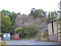
Penny Hill Quarry
A striking fragment of Wenlock Limestone from the Silurian, now one of the sites in the Abberley and Malvern Hills Geopark, accessible through a waste recycling site in the former quarry.
Image: © CHARLES GORDON CLARK
Taken: 11 Sep 2011
0.13 miles
3
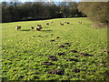
Sheep to the north of Hillend Farm
Sheep in a field to the north of Hillend Farm near martley.
Image: © Philip Halling
Taken: 30 Jan 2010
0.14 miles
4
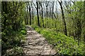
Worcestershire Way on Putford Hill
The Worcestershire Way passing through a springtime wood on Putford Hill.
Image: © Philip Halling
Taken: 19 Apr 2021
0.21 miles
5
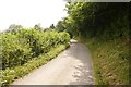
Road to Southwood
A quiet road, dead end for motors but you can get through to Shelsey Beauchamp by muscle power. It served a couple of farms and some cottages in a lovely setting.
Image: © Richard Webb
Taken: 1 Jul 2018
0.24 miles
7

A dry arable field
A dry tilled arable field in a valley between Penny Hill and Pudford Hill near Martley.
Image: © Philip Halling
Taken: 19 Apr 2021
0.25 miles