IMAGES TAKEN NEAR TO
Martley, WORCESTER, WR6 6QG
Introduction
This page details the photographs taken nearby to WR6 6QG by members of the Geograph project.
The Geograph project started in 2005 with the aim of publishing, organising and preserving representative images for every square kilometre of Great Britain, Ireland and the Isle of Man.

There are currently over 7.5m images from over14,400 individuals and you can help contribute to the project by visiting https://www.geograph.org.uk
Image Map
Images are licensed for reuse under creativecommons.org/licenses/by-sa/2.0
Notes
- Clicking on the map will re-center to the selected point.
- The higher the marker number, the further away the image location is from the centre of the postcode.
Image Listing (20 Images Found)
Images are licensed for reuse under creativecommons.org/licenses/by-sa/2.0
Image
Details
Distance
1
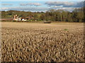
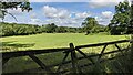
Stubble field and Brook Court, Martley
Brook Court viewed across a footpath crossing a stubble field. For more information on Brook Court see the English Heretige website: http://www.imagesofengland.org.uk/Details/Default.aspx?id=151657&mode=quick
Image: © Philip Halling
Taken: 30 Jan 2010
0.03 miles
2

Brook Hall
Obviously a very old dwelling but interesting that the 40's map has it as a farm
Image: © Andrew Darge
Taken: 22 Mar 2006
0.07 miles
3
The Malvern Hills (Viewed from Martley)
Here are the Malvern Hills from the 6½ mile Martley circular walk, and the hills seen from front to back are End Hill, North Hill and the Worcestershire Beacon, the latter of which is the tallest of the hill range at 1,394ft (425m) tall.
Image: © Fabian Musto
Taken: 5 Jul 2021
0.13 miles
4
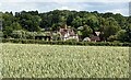
Brook Court (Martley)
Here is a timber-framed farmhouse from the early 17th century, and this is the grade II listed Brook Court on Horne Lane. This was given alterations in the 20th century.
Image: © Fabian Musto
Taken: 5 Jul 2021
0.13 miles
5
Fingerposts at Martley
These fingerposts are placed in a triangular road junction.
Image: © Fabian Musto
Taken: 5 Jul 2021
0.13 miles
6
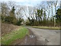
Road to Witton Hill
Country road to Witton Hill near Martley.
Image: © Philip Halling
Taken: 7 Mar 2017
0.14 miles
7
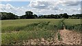
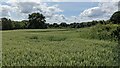
Field by the Martley Circular Walk
Here is one of many fields on the 6½ mile Martley circular walk, taken on the walk heading west to Hill Side.
Image: © Fabian Musto
Taken: 5 Jul 2021
0.14 miles
8
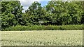
Field by the Martley Circular Walk
Here is one of many fields on the 6½ mile Martley circular walk, taken on the walk heading north to a country lane.
Image: © Fabian Musto
Taken: 5 Jul 2021
0.15 miles

10
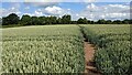
The Martley Circular Walk
Here is the 6½ mile Martley circular walk, which starts from St. Peter's parish church and heads to Rodge Hill, where the walk heads south to end at the same parish church. This section heads towards a country lane.
Image: © Fabian Musto
Taken: 5 Jul 2021
0.17 miles