IMAGES TAKEN NEAR TO
Millers Green, WORCESTER, WR6 6NY
Introduction
This page details the photographs taken nearby to Millers Green, WR6 6NY by members of the Geograph project.
The Geograph project started in 2005 with the aim of publishing, organising and preserving representative images for every square kilometre of Great Britain, Ireland and the Isle of Man.

There are currently over 7.5m images from over14,400 individuals and you can help contribute to the project by visiting https://www.geograph.org.uk
Image Map
Images are licensed for reuse under creativecommons.org/licenses/by-sa/2.0
Notes
- Clicking on the map will re-center to the selected point.
- The higher the marker number, the further away the image location is from the centre of the postcode.
Image Listing (76 Images Found)
Images are licensed for reuse under creativecommons.org/licenses/by-sa/2.0
Image
Details
Distance
1
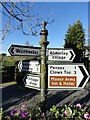
Direction Sign ? Signpost on the B4202 in Abberley
Located on the south side of the junction of the B4202 and The Common in Abberley parish. 5 modern arms and pawn finial.
Milestone Society National ID: WO_SO7467
Image: © Roadside Relics
Taken: 4 Nov 2021
0.03 miles
2
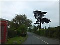
Clows Top Road, Abberley
The phone box in the village looks dusty - how often is it used?
Image: © David Smith
Taken: 20 May 2013
0.03 miles
3
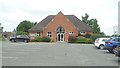
Abberley Parochial Primary School
Here is the Parochial primary school at Abberley, which is placed opposite the village hall.
Image: © Fabian Musto
Taken: 3 Jul 2020
0.04 miles
5
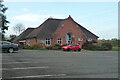
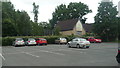
Abberley Village Hall
The brick structure seen here houses the village hall at Abberley, and it houses a ginormous car park that is commonly used by walkers on the Abberley Circular Walk and the nearby Parochial primary school.
Image: © Fabian Musto
Taken: 1 Nov 2020
0.06 miles
6
Abberley Parochial Primary School
Here is the Parochial primary school at Abberley, situated opposite the village hall.
Image: © Fabian Musto
Taken: 1 Nov 2020
0.06 miles
7
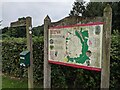
Information board at Abberley village hall
This information board talks about the five-mile Abberley Circular Walk, and there is a fingerpost that informs the walker to head west (east on OS map) on the circular walk.
Image: © Fabian Musto
Taken: 25 Aug 2021
0.06 miles
8
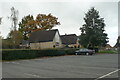
Abberley Village Hall
The brick structure seen here houses the village hall at Abberley, and it houses a ginormous car park that is commonly used by walkers on the Abberley Circular Walk and the nearby Parochial primary school.
Image: © Fabian Musto
Taken: 3 Jul 2020
0.06 miles
9
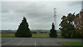
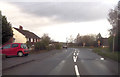
Pylon at Abberley
Taken from the car park at the village hall.
Image: © Fabian Musto
Taken: 1 Nov 2020
0.06 miles
10
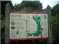
Information Board at Abberley Village Hall
Placed by the village hall car park is a useful information board about the Abberley Circular Walk. There are a handful of leaflets out-of-shot to the left that features a map of the 5 mile walk.
Image: © Fabian Musto
Taken: 3 Jul 2020
0.07 miles