IMAGES TAKEN NEAR TO
Ashpool, WORCESTER, WR6 5SD
Introduction
This page details the photographs taken nearby to Ashpool, WR6 5SD by members of the Geograph project.
The Geograph project started in 2005 with the aim of publishing, organising and preserving representative images for every square kilometre of Great Britain, Ireland and the Isle of Man.

There are currently over 7.5m images from over14,400 individuals and you can help contribute to the project by visiting https://www.geograph.org.uk
Image Map
Images are licensed for reuse under creativecommons.org/licenses/by-sa/2.0
Notes
- Clicking on the map will re-center to the selected point.
- The higher the marker number, the further away the image location is from the centre of the postcode.
Image Listing (10 Images Found)
Images are licensed for reuse under creativecommons.org/licenses/by-sa/2.0
Image
Details
Distance
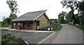
1
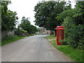
Whitbourne - phone box outside the village hall
Image: © Peter Whatley
Taken: 17 Jun 2008
0.04 miles
2
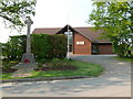
Whitbourne - Village Hall
Village Hall and War Memorial in the centre of Whitbourne village.
Image: © Tony Bailey
Taken: 7 May 2008
0.05 miles
3
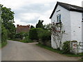
Whitbourne - Old Wheelwrights Cottage
Image: © Peter Whatley
Taken: 17 Jun 2008
0.07 miles
4
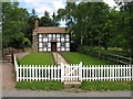
Chocolate Box
So cute it could be a model, but it isn't. An archetypal cottage in Whitbourne.
Image: © Peter Whatley
Taken: 17 Jun 2008
0.09 miles
5
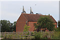
Oast House at Poplands Farm, Whitbourne
Image: © Oast House Archive
Taken: 29 Aug 2015
0.09 miles
6
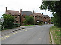
Whitbourne - row of new houses
One of which is named "Old Post Office". Site thereof perhaps.
Image: © Peter Whatley
Taken: 17 Jun 2008
0.10 miles
7
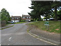
Meadow Green
Taken from outside the school.
Image: © Bob Embleton
Taken: 26 Sep 2005
0.10 miles
8
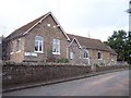
Whitbourne School, Meadow Green
Dated 1875
Image: © Bob Embleton
Taken: 26 Sep 2005
0.10 miles
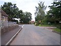
9
Whitbourne - Old Forge
Or a modern housing estate.
Image: © Peter Whatley
Taken: 17 Jun 2008
0.12 miles