IMAGES TAKEN NEAR TO
Sunningdale Estate, WORCESTER, WR6 5PP
Introduction
This page details the photographs taken nearby to Sunningdale Estate, WR6 5PP by members of the Geograph project.
The Geograph project started in 2005 with the aim of publishing, organising and preserving representative images for every square kilometre of Great Britain, Ireland and the Isle of Man.

There are currently over 7.5m images from over14,400 individuals and you can help contribute to the project by visiting https://www.geograph.org.uk
Image Map
Images are licensed for reuse under creativecommons.org/licenses/by-sa/2.0
Notes
- Clicking on the map will re-center to the selected point.
- The higher the marker number, the further away the image location is from the centre of the postcode.
Image Listing (7 Images Found)
Images are licensed for reuse under creativecommons.org/licenses/by-sa/2.0
Image
Details
Distance
1

Top of Ankerdine Hill
Ankerdine Hill, a steep climb out of the Teme Valley is a notorious test piece for roadies.
Image: © Richard Webb
Taken: 31 Mar 2019
0.12 miles
2

View west from the car park at Ankerdine Hill
Ankerdine Hill has a summit at 149 metres (489 ft) above sea level. This is the view west across the Teme valley towards the high ground of the Bromyard Downs.
Image: © Mat Fascione
Taken: 15 May 2021
0.12 miles
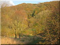
3

Hay Wood
Steep wooded slopes above the Teme on Ankerdine Hill.
Image: © Richard Webb
Taken: 31 Mar 2019
0.13 miles
4
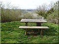
Picnic table, Ankerdine Hill
A big view into Herefordshire from a very well placed picnic table.
Image: © Richard Webb
Taken: 31 Mar 2019
0.22 miles
5
Ankerdine Hill
A cottage is hidden among the trees.
Image: © Jonathan Thacker
Taken: 22 Nov 2013
0.22 miles
6
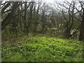
Spring growth, Ankerdine Hill
Not the infamous road climb, but the summit above. I only climbed from Martley.
Image: © Richard Webb
Taken: 31 Mar 2019
0.24 miles
7
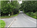
B4197 at Collins Green
A brief level section on the severe climb up Ankerdine Hill.
Image: © Peter Whatley
Taken: 29 Jul 2008
0.25 miles