IMAGES TAKEN NEAR TO
Broadwas, WORCESTER, WR6 5NS
Introduction
This page details the photographs taken nearby to WR6 5NS by members of the Geograph project.
The Geograph project started in 2005 with the aim of publishing, organising and preserving representative images for every square kilometre of Great Britain, Ireland and the Isle of Man.

There are currently over 7.5m images from over14,400 individuals and you can help contribute to the project by visiting https://www.geograph.org.uk
Image Map
Images are licensed for reuse under creativecommons.org/licenses/by-sa/2.0
Notes
- Clicking on the map will re-center to the selected point.
- The higher the marker number, the further away the image location is from the centre of the postcode.
Image Listing (8 Images Found)
Images are licensed for reuse under creativecommons.org/licenses/by-sa/2.0
Image
Details
Distance
1
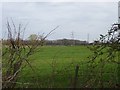
Field by Browncroft
Grassland west of Broadheath.
Image: © Richard Webb
Taken: 31 Mar 2019
0.10 miles
2
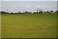
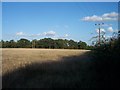
Farmland and Allsetts Farm
Farmland and Allsetts Farm which can be seen to the right in the middle distance.
Image: © Philip Halling
Taken: 14 Apr 2018
0.11 miles
4
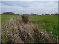
Brook by Brownscroft
Dug into a drain.
Image: © Richard Webb
Taken: 31 Mar 2019
0.12 miles
5
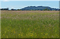
View across the meadow to Berrow Hill
The hill is nearly 4 kilometres away.
Image: © Mat Fascione
Taken: 12 Jun 2014
0.14 miles
6
Woodland strip near Allsetts Farm
The footpath runs along the hedge on what must have been an old road.
Image: © Bob Embleton
Taken: 27 Sep 2005
0.22 miles
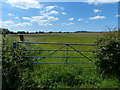
7
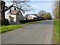
Blackfields Farm
Blackfields Farm near Broad Green.
Image: © Philip Halling
Taken: 18 Apr 2021
0.24 miles
8
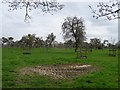
March, and the pear blossom is out
Orchard, The Lingens near Broadheath.
Image: © Richard Webb
Taken: 31 Mar 2019
0.25 miles