IMAGES TAKEN NEAR TO
Cobblers Corner, WORCESTER, WR6 5NP
Introduction
This page details the photographs taken nearby to Cobblers Corner, WR6 5NP by members of the Geograph project.
The Geograph project started in 2005 with the aim of publishing, organising and preserving representative images for every square kilometre of Great Britain, Ireland and the Isle of Man.

There are currently over 7.5m images from over14,400 individuals and you can help contribute to the project by visiting https://www.geograph.org.uk
Image Map
Images are licensed for reuse under creativecommons.org/licenses/by-sa/2.0
Notes
- Clicking on the map will re-center to the selected point.
- The higher the marker number, the further away the image location is from the centre of the postcode.
Image Listing (7 Images Found)
Images are licensed for reuse under creativecommons.org/licenses/by-sa/2.0
Image
Details
Distance
2
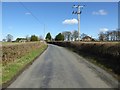
Road approaching Cobbler's Corner
Country road from Broadwas approaching Cobbler's Corner.
Image: © Philip Halling
Taken: 7 Mar 2017
0.06 miles
4
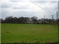
Farmland to the north of Broad Green
View across farmland to the north of Broad Green.
Image: © Philip Halling
Taken: 7 Mar 2017
0.13 miles
5
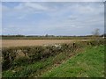
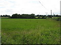
West of Worcester
Arable land near Cobbler's Corner.
Image: © Richard Webb
Taken: 31 Mar 2019
0.20 miles
6
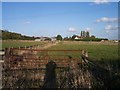
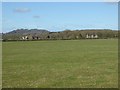
Woodend Farm
A large farm whose origins are on a moated site.
Image: © Bob Embleton
Taken: 27 Sep 2005
0.23 miles
7
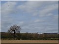
Corvids in Worcestershire
A flock of rooks and jackdaws working the cultivated land north of Cobbler's Corner.
Image: © Richard Webb
Taken: 31 Mar 2019
0.23 miles