IMAGES TAKEN NEAR TO
Dingle Road, WORCESTER, WR6 5JX
Introduction
This page details the photographs taken nearby to Dingle Road, WR6 5JX by members of the Geograph project.
The Geograph project started in 2005 with the aim of publishing, organising and preserving representative images for every square kilometre of Great Britain, Ireland and the Isle of Man.

There are currently over 7.5m images from over14,400 individuals and you can help contribute to the project by visiting https://www.geograph.org.uk
Image Map
Images are licensed for reuse under creativecommons.org/licenses/by-sa/2.0
Notes
- Clicking on the map will re-center to the selected point.
- The higher the marker number, the further away the image location is from the centre of the postcode.
Image Listing (15 Images Found)
Images are licensed for reuse under creativecommons.org/licenses/by-sa/2.0
Image
Details
Distance
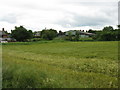
1
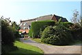
Haymaking at Brockamin
A field a cut grass drying ready for making into hay.
Image: © Philip Halling
Taken: 12 Jul 2013
0.05 miles
2
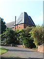
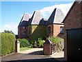
Oast House at Greathouse Farm, Leigh
Image: © Oast House Archive
Taken: 11 Sep 2014
0.08 miles
5
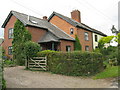
Converted Oast Houses, Greathouse Farm
Complete with CCTV surveillance camera and IR lighting!
Image: © Bob Embleton
Taken: 25 Sep 2005
0.12 miles
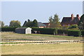
6
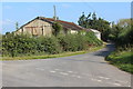
Brockamin - two cottages
Found opposite Little Brockamin Farm.
Image: © Peter Whatley
Taken: 11 Jun 2008
0.16 miles
7
Oast House at Pigeonhouse Court, Dingle Road, Leigh
Image: © Oast House Archive
Taken: 11 Sep 2014
0.19 miles
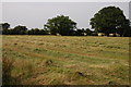
9
Gate to Brockamin Fisheries
The track drops down to the flatlands of the River Teme valley.
Image: © Bob Embleton
Taken: 20 Sep 2005
0.21 miles