IMAGES TAKEN NEAR TO
Bishops Frome, WORCESTER, WR6 5BQ
Introduction
This page details the photographs taken nearby to WR6 5BQ by members of the Geograph project.
The Geograph project started in 2005 with the aim of publishing, organising and preserving representative images for every square kilometre of Great Britain, Ireland and the Isle of Man.

There are currently over 7.5m images from over14,400 individuals and you can help contribute to the project by visiting https://www.geograph.org.uk
Image Map
Images are licensed for reuse under creativecommons.org/licenses/by-sa/2.0
Notes
- Clicking on the map will re-center to the selected point.
- The higher the marker number, the further away the image location is from the centre of the postcode.
Image Listing (6 Images Found)
Images are licensed for reuse under creativecommons.org/licenses/by-sa/2.0
Image
Details
Distance
1
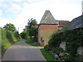
The Dovehills, Bishops Frome, Herefordshire
Rhea Farm with its twin square roofed oast houses is behind.
Taken from the bridleway close to Stanford Bishop church.
Image: © Bob Embleton
Taken: 6 Aug 2013
0.02 miles
2
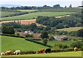
Dovehills Farm, Bishops Frome
From the footpath from Acton Beauchamp to Stanford Bishop.
The parish boundary follows the Whelpley Brook which flows in the bottom of this valley.
Image: © Bob Embleton
Taken: 6 Aug 2013
0.02 miles
3

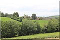
Footpath above the Frome valley
Footpath above the Frome valley near The Dovehills Farm.
Image: © Philip Halling
Taken: 22 Apr 2021
0.16 miles
4
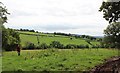
Rough pasture, Stanford Bishop
Walking the footpath from Acton Beauchamp church.
Image: © Bob Embleton
Taken: 6 Aug 2013
0.21 miles
5
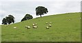
Sheep pasture, Acton Beauchamp
Taken from close to the footbridge over the Whelpley Brook which forms the parish boundary between Acton Beauchamp and Stanford Bishop.
The OS map shows a "Ford" near here, but we didn't spot it.
Image: © Bob Embleton
Taken: 6 Aug 2013
0.22 miles