IMAGES TAKEN NEAR TO
Pippins Hill, WORCESTER, WR6 5AD
Introduction
This page details the photographs taken nearby to Pippins Hill, WR6 5AD by members of the Geograph project.
The Geograph project started in 2005 with the aim of publishing, organising and preserving representative images for every square kilometre of Great Britain, Ireland and the Isle of Man.

There are currently over 7.5m images from over14,400 individuals and you can help contribute to the project by visiting https://www.geograph.org.uk
Image Map
Images are licensed for reuse under creativecommons.org/licenses/by-sa/2.0
Notes
- Clicking on the map will re-center to the selected point.
- The higher the marker number, the further away the image location is from the centre of the postcode.
Image Listing (3 Images Found)
Images are licensed for reuse under creativecommons.org/licenses/by-sa/2.0
Image
Details
Distance
1

Halfridge
View from Stanford Bishop churchyard with the Malvern Hills in the background.
Image: © Richard Webb
Taken: 16 Feb 2019
0.15 miles
2
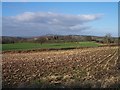
Maize Stubble, Halfridge Farm
Taken from the track to the farm looking north towards the Bromyard downs in the distance.
Image: © Bob Embleton
Taken: 21 Jan 2006
0.18 miles
3
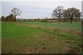
Farmland near Acton Green
Farmland opposite Freith Farm near Acton Green.
Image: © Philip Halling
Taken: 28 Dec 2015
0.23 miles