IMAGES TAKEN NEAR TO
Bullfinch Close, WORCESTER, WR5 3SL
Introduction
This page details the photographs taken nearby to Bullfinch Close, WR5 3SL by members of the Geograph project.
The Geograph project started in 2005 with the aim of publishing, organising and preserving representative images for every square kilometre of Great Britain, Ireland and the Isle of Man.

There are currently over 7.5m images from over14,400 individuals and you can help contribute to the project by visiting https://www.geograph.org.uk
Image Map
Images are licensed for reuse under creativecommons.org/licenses/by-sa/2.0
Notes
- Clicking on the map will re-center to the selected point.
- The higher the marker number, the further away the image location is from the centre of the postcode.
Image Listing (89 Images Found)
Images are licensed for reuse under creativecommons.org/licenses/by-sa/2.0
Image
Details
Distance
1
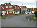
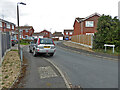
Bullfinch Close from Bittern Drive, St Peter The Great
This segment of the large housing development has a bird theme. Like Warndon Villages at the other side of Worcester, the architecture is one of a spine road from which branch secondary roads carrying groups of cul-de-sacs. The various sections are linked together by plentiful footpaths. although some routes are blind even on foot.
Image: © Chris Allen
Taken: 21 Mar 2021
0.04 miles
2
St Peter's Drive, St Peter The Great, Worcester
A large modern housing development that abuts the Worcester Bypass. This is the main spine road that loops through the middle of the complex.
Image: © Chris Allen
Taken: 21 Mar 2021
0.04 miles
3
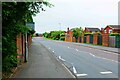
St. Peter's Drive
An arterial road to the huge housing estate. No houses have direct access to this road, but are hidden behind brick walls.
Image: © Bob Embleton
Taken: 23 Sep 2007
0.04 miles
4
The blind end of Larkspur Road, St Peter The Great
A cul-de-sac with no alternative pedestrian exit. I had to turn round and go back to where I had come from.
Image: © Chris Allen
Taken: 21 Mar 2021
0.06 miles
5
Swallow Close from Bittern Road, St Peter The Great, Worcester
Image: © Chris Allen
Taken: 21 Mar 2021
0.06 miles
6
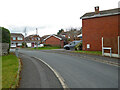
St. Peter's Drive, St. Peter's, Worcester
St. Peter's Drive forms a loop, and acts as a spine road for the residential estates in this area.
Image: © P L Chadwick
Taken: 4 Jun 2022
0.07 miles
7
Partridge Close, St Peter The Great
A cul-de-sac off Bittern Road in this large housing complex.
Image: © Chris Allen
Taken: 21 Mar 2021
0.07 miles
8
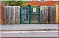
Electricity sub-station, St. Peter's Drive, St. Peter's, Worcester
Sub-station serving the many residential roads nearby.
Image: © P L Chadwick
Taken: 4 Jun 2022
0.07 miles
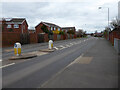
9
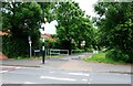
Norton Road, St. Peter's, Worcester
The zebra crossing in the foreground is on St. Peter's Drive. Ahead of this is part of Norton Road, which here is a footpath and cycleway. In this direction it leads to Power Park, a linear public park, and Broomhall Green, a residential road.
Image: © P L Chadwick
Taken: 4 Jun 2022
0.08 miles
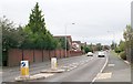
10

Norton Road, St. Peter's, Worcester
In the foreground is St. Peter's Drive. Norton Road is here a footpath and cycleway, but later it becomes a residential road, which also has vehicular traffic. The black bin is a large litter bin, of which there are many to be found in this area.
Image: © P L Chadwick
Taken: 4 Jun 2022
0.09 miles