IMAGES TAKEN NEAR TO
Heather Close, WORCESTER, WR5 3LX
Introduction
This page details the photographs taken nearby to Heather Close, WR5 3LX by members of the Geograph project.
The Geograph project started in 2005 with the aim of publishing, organising and preserving representative images for every square kilometre of Great Britain, Ireland and the Isle of Man.

There are currently over 7.5m images from over14,400 individuals and you can help contribute to the project by visiting https://www.geograph.org.uk
Image Map
Images are licensed for reuse under creativecommons.org/licenses/by-sa/2.0
Notes
- Clicking on the map will re-center to the selected point.
- The higher the marker number, the further away the image location is from the centre of the postcode.
Image Listing (200 Images Found)
Images are licensed for reuse under creativecommons.org/licenses/by-sa/2.0
Image
Details
Distance
1

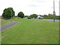
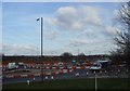
The Malverns in the guise of Alps in winter
The tracks show how well used this stretch of grassland beneath the powerlines south of Worcester is.
Image: © Andrew Darge
Taken: 19 Feb 2010
0.03 miles
2

Heather Close play area, St Peter the Great
The path links Heather Close to Celandine Drive. All the streets in this corner of the relatively modern development are named after plants.
Image: © Chris Allen
Taken: 14 Oct 2020
0.03 miles
3
St Peter's by-pass
The Worcester by-pass skirting the housing estate at St Peter The Great. Although space was taken for a dual carriageway, only half the road has been built.
Image: © Peter Whatley
Taken: 24 Jun 2008
0.04 miles
4
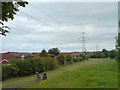
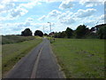
Powerlines and path from Power Park
A well maintained bit of green between the St Peters estate and the A4440 southern link road . The powerlines feed a substation beside the old Norton road and then continue north and east around Worcester beside the M5.
Image: © Andrew Darge
Taken: 28 May 2009
0.04 miles
5
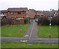
Path into St.Peters estate
This is the point at which the path of the roman road enters the suburbs of Worcester.
Image: © Andrew Darge
Taken: 2 Jan 2008
0.04 miles
6

Millennium oak
This tree planted originally by the footpath around the Ketch roundabout has happily been moved bodily to this new location away from the road works.
Image: © Andrew Darge
Taken: 5 Jun 2014
0.05 miles
7
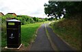
Footpath and cycleway, Power Park, St. Peter's, Worcester
Photographed from near the short lane to Orchid Close.
A closer view of the litter bin:- Image
Image: © P L Chadwick
Taken: 9 Jul 2022
0.05 miles
8
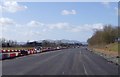
A4440 roadworks
The new road layout beginning to take shape
Image: © Andrew Darge
Taken: 3 Feb 2015
0.05 miles
9
Roman crossing
The path off to the right most nearly marks the route of the roman road into Worcester from the south
Image
Image: © Andrew Darge
Taken: 16 Jun 2008
0.06 miles
10
Fresh tarmac
Looking more like an aircraft runway the new carriageway is nearly ready to have a centre barrier and lane markings .
Image: © Andrew Darge
Taken: 10 Mar 2015
0.06 miles