IMAGES TAKEN NEAR TO
Windmill Lane, WORCESTER, WR5 3LL
Introduction
This page details the photographs taken nearby to Windmill Lane, WR5 3LL by members of the Geograph project.
The Geograph project started in 2005 with the aim of publishing, organising and preserving representative images for every square kilometre of Great Britain, Ireland and the Isle of Man.

There are currently over 7.5m images from over14,400 individuals and you can help contribute to the project by visiting https://www.geograph.org.uk
Image Map
Images are licensed for reuse under creativecommons.org/licenses/by-sa/2.0
Notes
- Clicking on the map will re-center to the selected point.
- The higher the marker number, the further away the image location is from the centre of the postcode.
Image Listing (43 Images Found)
Images are licensed for reuse under creativecommons.org/licenses/by-sa/2.0
Image
Details
Distance
1
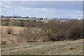
The edge of Kempsey, Worcestershire
King's Hill is the last road in Kempsey before the flood plain of the River Severn. The Malvern Hills can be seen in the distance.
Image: © Jeff Gogarty
Taken: 27 Nov 2015
0.04 miles
2

Kempsey Community Centre
Kempsey Community Centre on the side of the A38 passing through Kempsey.
Image: © Philip Halling
Taken: 17 Feb 2025
0.06 miles
3
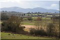
View to the Malvern Hills
View from King's Hill in Kempsey to the Malvern Hills across meadowland.
Image: © Philip Halling
Taken: 21 Feb 2015
0.07 miles
4
Main Road in Kempsey
Still heading for the centre of the village. This path is a temporary diversion for the Severn Way while the River Severn is flooded.
Image: © Bill Boaden
Taken: 16 Nov 2019
0.08 miles
5
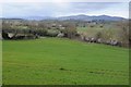
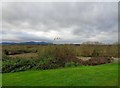
View to the Malvern Hills
View across the Severn floodplain to the Malvern Hills, viewed from King's Hill, Kempsey.
Image: © Philip Halling
Taken: 22 Mar 2014
0.09 miles
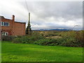
6
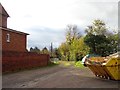
Road to garages, Windmill Lane, Kempsey, Worcestershire
The last buildings on the edge of Kempsey before it drops down to the Severn flood plain.
Image: © Jeff Gogarty
Taken: 27 Nov 2015
0.10 miles
7
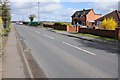
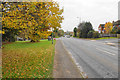
The A38 at Kempsey
The A38 at the northern edge of the village of Kempsey. An Upton bound 362 bus is approaching.
Image: © Philip Halling
Taken: 22 Mar 2014
0.11 miles
8
View to Powick
View to Powick across the Severn floodplain from King's Hill, Kempsey. Powick church is clearly seen.
Image: © Philip Halling
Taken: 21 Feb 2015
0.11 miles
9
View from King's Hill, Kempsey, Worcestershire
The willows of the left are where a drain flows down to the River Severn. It the distance is the Malvern Hills.
Image: © Jeff Gogarty
Taken: 27 Nov 2015
0.11 miles
10
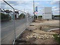
Building site in Kempsey
The fenced off entrance to a building site beside the A38 on the northern edge of Kempsey.
Image: © Philip Halling
Taken: 1 May 2015
0.12 miles