IMAGES TAKEN NEAR TO
St. Marys Close, WORCESTER, WR5 3JX
Introduction
This page details the photographs taken nearby to St. Marys Close, WR5 3JX by members of the Geograph project.
The Geograph project started in 2005 with the aim of publishing, organising and preserving representative images for every square kilometre of Great Britain, Ireland and the Isle of Man.

There are currently over 7.5m images from over14,400 individuals and you can help contribute to the project by visiting https://www.geograph.org.uk
Image Map
Images are licensed for reuse under creativecommons.org/licenses/by-sa/2.0
Notes
- Clicking on the map will re-center to the selected point.
- The higher the marker number, the further away the image location is from the centre of the postcode.
Image Listing (141 Images Found)
Images are licensed for reuse under creativecommons.org/licenses/by-sa/2.0
Image
Details
Distance
1
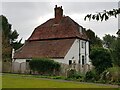
34 Church Street, Ombersley
Probably early 18th century with timber framing and a thatched roof. Listed Grade II.
Image: © Chris Allen
Taken: 1 Feb 2022
0.03 miles
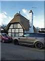
2
Cromwell Cottage
https://historicengland.org.uk/listing/the-list/list-entry/1098796?section=official-list-entry
Image: © Sandy Gerrard
Taken: 2 May 2024
0.03 miles
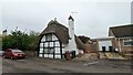
3
Peckwater Cottage, Church Street, Kempsey
Late 17th century with timber frame and thatched roof. Listed Grade II.
Image: © Chris Allen
Taken: 1 Feb 2022
0.03 miles
4
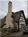
Peckwater Cottage, 36, Church Street, Kempsey
One of two listed thatched cottages on Church Street. The other, Cromwell Cottage, was being re-thatched but that is now complete.
Peckwater Cottage was formerly known as Cobbler's Cottage. It is late 17th century.
Image: © Jeff Gogarty
Taken: 17 Sep 2021
0.04 miles
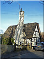
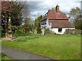
5
House on Church Street, Kempsey, Worcestershire
Image: © Jeff Gogarty
Taken: 17 Sep 2021
0.09 miles
6
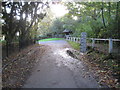
Kempsey: Squire's Walk and water level gaugeboard
On the right is a water level gaugeboard, which shows the depth of water at the ford across Hatfield Brook, which itself is just around the corner to the left. Some indication of the depth of water that was expected at the ford in historic times can be gleaned from the fact that the base of the gaugeboard is at 7 feet. Philip's Image taken round the corner shows the "lower half" of the gaugeboard. Hopefully, with the completion in September 2012 of Kempsey's flood protection embankment, that keeps floodwater from the River Severn out of the village, and pumps that take excess water from the brook into the river, there will be no more need for such a gauge. However the pumps failed to operate as planned in a flood event in November 2012, and some properties in the village were flooded again.
Image: © Nigel Cox
Taken: 26 Oct 2013
0.10 miles

8

Flooded Kempsey Ford
Kempsey Ford is impassable after recent heavy rain has swollen the Hatfield Brook.
Image: © Philip Halling
Taken: 9 Dec 2007
0.10 miles
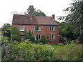
9
Church House
Church House is a part-timbered and dating from the early 18th century, here it is viewed from the churchyard. It is Grade II listed.
Historic England description
KEMPSEY CP - SO 8449-8549 9/15 Church House 25.3.68 GV II House. Early C18, altered C20. Timber-framing with brick infill and tiled mansard roof. Two storeys with attic, three bays. Straight tension braces rise from the rail at ground floor ceiling level to the principal posts. Windows have metal casements. Two attic dormers. Door in middle bay. To the left and right are flank walls concealing single-storey lean-tos. Each has a doorway with pointed head. Chimneys on ridge near centre and towards right. It would appear that the building was originally intended to be clad; the framing has been exposed during the C20.
Source: https://www.historicengland.org.uk/listing/the-list/list-entry/1098797
Image: © Philip Halling
Taken: 29 Apr 2016
0.10 miles