IMAGES TAKEN NEAR TO
Riverside Place, WORCESTER, WR5 3JS
Introduction
This page details the photographs taken nearby to Riverside Place, WR5 3JS by members of the Geograph project.
The Geograph project started in 2005 with the aim of publishing, organising and preserving representative images for every square kilometre of Great Britain, Ireland and the Isle of Man.

There are currently over 7.5m images from over14,400 individuals and you can help contribute to the project by visiting https://www.geograph.org.uk
Image Map
Images are licensed for reuse under creativecommons.org/licenses/by-sa/2.0
Notes
- Clicking on the map will re-center to the selected point.
- The higher the marker number, the further away the image location is from the centre of the postcode.
Image Listing (121 Images Found)
Images are licensed for reuse under creativecommons.org/licenses/by-sa/2.0
Image
Details
Distance
1
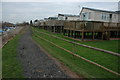
Mobile homes, Kempsey
Mobile homes overlooking moorings on the River Severn at Kempsey.
Image: © Philip Halling
Taken: 23 Jan 2011
0.04 miles
2
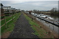
Severn Way at Kempsey
The Severn Way passing a mobile homes park and moorings on the River Severn at Kempsey.
Image: © Philip Halling
Taken: 23 Jan 2011
0.05 miles
3
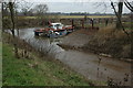
Slipway at Kempsey
Slipway to the River Severn at Kempsey.
Image: © Philip Halling
Taken: 23 Jan 2011
0.08 miles
5
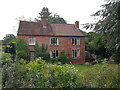
House on Church Street, Kempsey, Worcestershire
Image: © Jeff Gogarty
Taken: 17 Sep 2021
0.11 miles
7

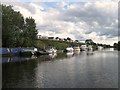
Slipway, Kempsey
The slipway seen from the river.
Image: © Pierre Terre
Taken: 17 May 2009
0.12 miles