IMAGES TAKEN NEAR TO
Carp Close, WORCESTER, WR5 3FJ
Introduction
This page details the photographs taken nearby to Carp Close, WR5 3FJ by members of the Geograph project.
The Geograph project started in 2005 with the aim of publishing, organising and preserving representative images for every square kilometre of Great Britain, Ireland and the Isle of Man.

There are currently over 7.5m images from over14,400 individuals and you can help contribute to the project by visiting https://www.geograph.org.uk
Image Map
Images are licensed for reuse under creativecommons.org/licenses/by-sa/2.0
Notes
- Clicking on the map will re-center to the selected point.
- The higher the marker number, the further away the image location is from the centre of the postcode.
Image Listing (69 Images Found)
Images are licensed for reuse under creativecommons.org/licenses/by-sa/2.0
Image
Details
Distance
1
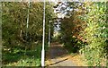
New path to the Severn
Part of the redevelopment of the old oil storage site beside the Bath road south of Worcester
Image: © Andrew Darge
Taken: 25 Oct 2009
0.05 miles
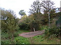
3
Oil jetty
The landward side of the landing jetty for the tankers bring oil up the Severn to the storage site beside the Bath road now cleared and developed with houses.
Image: © Andrew Darge
Taken: 25 Oct 2009
0.08 miles
4

Bus shelter
Bus shelter on the A38 entering Worcester. The pole on the left marks the line of a oil pipeline installed in 1942 between Liverpool’s Stanlow Refinery with Bristol’s Avonmouth Docks.
Image: © Philip Halling
Taken: 17 Feb 2025
0.08 miles
5
New path to the Severn
Now that the development of the old oil storage site is complete the gates have been opened allowing a new path from the riverside walk up to the Bath road.
Image: © Andrew Darge
Taken: 25 Oct 2009
0.09 miles
6
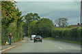
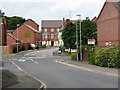
St Peter the Great County : Bath Road A38
Looking along Bath Road.
Image: © Lewis Clarke
Taken: 29 Sep 2019
0.09 miles
7
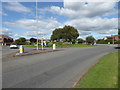
Roundabout on the Bath Road, Worcester
This is by the Timberdine at the junction with St Peter's Drive.
Image: © Chris Allen
Taken: 29 Aug 2020
0.10 miles
8
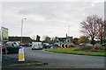
Roundabout on Bath Road
The traffic is tailing back from the southern ring road.
Image: © Bill Boaden
Taken: 16 Nov 2019
0.10 miles
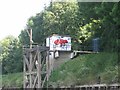
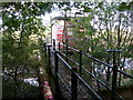
10
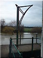
Simple hoist
On the end of the oil jetty, probably to assist with attaching the discharge hose beneath this platform. Note the river is well up.
Image: © Andrew Darge
Taken: 21 Nov 2009
0.11 miles