IMAGES TAKEN NEAR TO
Norton Close, WORCESTER, WR5 3EY
Introduction
This page details the photographs taken nearby to Norton Close, WR5 3EY by members of the Geograph project.
The Geograph project started in 2005 with the aim of publishing, organising and preserving representative images for every square kilometre of Great Britain, Ireland and the Isle of Man.

There are currently over 7.5m images from over14,400 individuals and you can help contribute to the project by visiting https://www.geograph.org.uk
Image Map
Images are licensed for reuse under creativecommons.org/licenses/by-sa/2.0
Notes
- Clicking on the map will re-center to the selected point.
- The higher the marker number, the further away the image location is from the centre of the postcode.
Image Listing (41 Images Found)
Images are licensed for reuse under creativecommons.org/licenses/by-sa/2.0
Image
Details
Distance
1
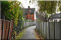
Path off St Mark's Close
Running through to Barneshall Avenue.
Image: © Bill Boaden
Taken: 16 Nov 2019
0.08 miles
2
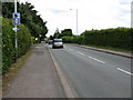
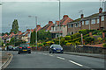
Bath Road (2)
No excuses for getting caught by the speed camera: it's at the top of a speed-sapping hill and visible from 200 yards away!
Image: © Peter Whatley
Taken: 24 Jun 2008
0.10 miles
3
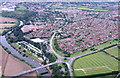
Carrington bridge and the Bath road into Worcester
The straight section in the middle distance can be traced south and is the alignment of the roman road out of Worcester
Image: © Andrew Darge
Taken: 17 Aug 2007
0.10 miles
4
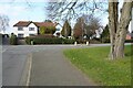
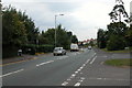
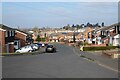
Norton Road
Junction of Norton Road with Bath Road.
Image: © Philip Halling
Taken: 13 Feb 2023
0.11 miles
5
Bath Road, Worcester
Bath Road, Worcester at the junction with the old road to Norton.
Image: © Philip Halling
Taken: 13 Sep 2005
0.12 miles
6
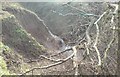
Duck Brook 'force'
With a good flow down the brook from recent rain and with the river fairly low , it takes longer for runoff from the welsh headwaters to reach here , a small waterfall appears .
Image: © Andrew Darge
Taken: 21 Mar 2010
0.13 miles
7
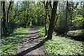
Footpath beside the River Severn
Footpath beside the River Severn, this is also the route of the Severn Way and Three Choirs Way.
Image: © Philip Halling
Taken: 19 Apr 2018
0.14 miles
8
Worcester : Bath Road A38
Looking along Bath Road through Worcester.
Image: © Lewis Clarke
Taken: 29 Sep 2019
0.14 miles
9
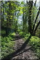
Footpath beside Duck Brook
Footpath beside Duck Brook just before it flows into the River Severn to the south of Worcester. Both the Severn Way and Three Choirs Way cross this footpath.
Image: © Philip Halling
Taken: 19 Apr 2018
0.14 miles
10
St Mark's Close
St Mark's Close in Worcester, the tower of the cathedral can be seen on the horizon.
Image: © Philip Halling
Taken: 13 Feb 2023
0.14 miles