IMAGES TAKEN NEAR TO
Aycliffe Road, WORCESTER, WR5 3AZ
Introduction
This page details the photographs taken nearby to Aycliffe Road, WR5 3AZ by members of the Geograph project.
The Geograph project started in 2005 with the aim of publishing, organising and preserving representative images for every square kilometre of Great Britain, Ireland and the Isle of Man.

There are currently over 7.5m images from over14,400 individuals and you can help contribute to the project by visiting https://www.geograph.org.uk
Image Map
Images are licensed for reuse under creativecommons.org/licenses/by-sa/2.0
Notes
- Clicking on the map will re-center to the selected point.
- The higher the marker number, the further away the image location is from the centre of the postcode.
Image Listing (35 Images Found)
Images are licensed for reuse under creativecommons.org/licenses/by-sa/2.0
Image
Details
Distance
1
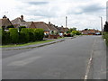
Norton Avenue
Norton Avenue was once a direct route between Worcester and the village of Norton. It survives as several, isolated sections, severed by new housing estates and Worcester's bypass. Photo taken at the junction with Arden Road.
Image: © Peter Whatley
Taken: 24 Jun 2008
0.04 miles
2
Tour de Worcester
These enthusiasts have got into the cycling bug; one even sports a yellow jersey.
Image: © Andrew Darge
Taken: 23 Jul 2012
0.07 miles
3
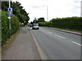
Bath Road (2)
No excuses for getting caught by the speed camera: it's at the top of a speed-sapping hill and visible from 200 yards away!
Image: © Peter Whatley
Taken: 24 Jun 2008
0.08 miles
4
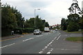
Bath Road, Worcester
Bath Road, Worcester at the junction with the old road to Norton.
Image: © Philip Halling
Taken: 13 Sep 2005
0.08 miles
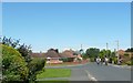
6
Partridge Close, St Peter The Great
A cul-de-sac off Bittern Road in this large housing complex.
Image: © Chris Allen
Taken: 21 Mar 2021
0.09 miles
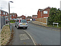
8
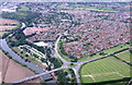
Carrington bridge and the Bath road into Worcester
The straight section in the middle distance can be traced south and is the alignment of the roman road out of Worcester
Image: © Andrew Darge
Taken: 17 Aug 2007
0.10 miles
9
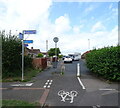
Junction on National Cycle Route 45, St Peter The Great, Worcester
Image: © JThomas
Taken: 13 Aug 2021
0.10 miles
10
Swallow Close from Bittern Road, St Peter The Great, Worcester
Image: © Chris Allen
Taken: 21 Mar 2021
0.10 miles