IMAGES TAKEN NEAR TO
Kilbury Drive, WORCESTER, WR5 2NE
Introduction
This page details the photographs taken nearby to Kilbury Drive, WR5 2NE by members of the Geograph project.
The Geograph project started in 2005 with the aim of publishing, organising and preserving representative images for every square kilometre of Great Britain, Ireland and the Isle of Man.

There are currently over 7.5m images from over14,400 individuals and you can help contribute to the project by visiting https://www.geograph.org.uk
Image Map
Images are licensed for reuse under creativecommons.org/licenses/by-sa/2.0
Notes
- Clicking on the map will re-center to the selected point.
- The higher the marker number, the further away the image location is from the centre of the postcode.
Image Listing (95 Images Found)
Images are licensed for reuse under creativecommons.org/licenses/by-sa/2.0
Image
Details
Distance
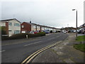
1
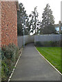
Path from Dalziel Drive to Kilbury Drive, Worcester
This leads from a new housing development to an older development.
Image: © Chris Allen
Taken: 15 Mar 2021
0.01 miles
2
Public footpath from Kilbury Drive, Worcester
This leads to a new housing development but is obviously a pre-existing right of way.
Image: © Chris Allen
Taken: 15 Mar 2021
0.02 miles
3
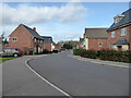
Dalziel Drive, Worcester
A long and serpentine road within a new housing development.
Image: © Chris Allen
Taken: 15 Mar 2021
0.03 miles
4
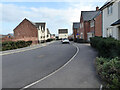
Dalziel Drive, Worcester
A long and serpentine road in this new housing development.
Image: © Chris Allen
Taken: 15 Mar 2021
0.03 miles
5
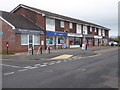
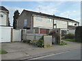
Local shops, Kilbury Drive
A Sunday stroll found me in previously unvisited areas and I couldn't resist a shot of the local amenities.
Image: © Chris Allen
Taken: 13 Jan 2019
0.04 miles
7
Baynham Drive, Worcester
Kilbury Drive is in the distance at a T-junction. On the right is Bronsil Close. This provides a route on foot to the new Weogoran Park development.
Image: © Chris Allen
Taken: 15 Mar 2021
0.06 miles
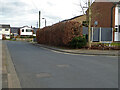
8
Between the new and the old
On the other side of the bollards is Staplow Road on the well-established Red Hill estate. I am on Dalziel Drive on the new Hatton Grange estate.
Image: © Chris Allen
Taken: 22 Oct 2017
0.06 miles
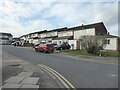
9
Dinchall Road, Worcester
On one of the older estates. Including a name sign helps in locating shots some months later.
Image: © Chris Allen
Taken: 13 Jan 2019
0.08 miles
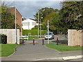
10
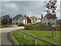
Dalziel Drive, Hatton Grange, Worcester
A large Persimmon development. A small stream cuts through below the white railings. To the right behind the bushes is Gradison Gardens. To the right just behind me is Leslie Walk. I was staggered by how long I spent wandering around this complex and I certainly didn't see every nook and cranny.
Image: © Chris Allen
Taken: 22 Oct 2017
0.08 miles