IMAGES TAKEN NEAR TO
Aylton Close, WORCESTER, WR5 2LY
Introduction
This page details the photographs taken nearby to Aylton Close, WR5 2LY by members of the Geograph project.
The Geograph project started in 2005 with the aim of publishing, organising and preserving representative images for every square kilometre of Great Britain, Ireland and the Isle of Man.

There are currently over 7.5m images from over14,400 individuals and you can help contribute to the project by visiting https://www.geograph.org.uk
Image Map
Images are licensed for reuse under creativecommons.org/licenses/by-sa/2.0
Notes
- Clicking on the map will re-center to the selected point.
- The higher the marker number, the further away the image location is from the centre of the postcode.
Image Listing (137 Images Found)
Images are licensed for reuse under creativecommons.org/licenses/by-sa/2.0
Image
Details
Distance
1
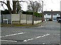
Aylton Close from Spetchley Road, Worcester
Image: © Chris Allen
Taken: 11 Mar 2021
0.02 miles
2
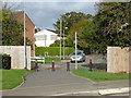
Between the new and the old
On the other side of the bollards is Staplow Road on the well-established Red Hill estate. I am on Dalziel Drive on the new Hatton Grange estate.
Image: © Chris Allen
Taken: 22 Oct 2017
0.04 miles
3
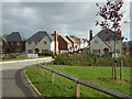
Dalziel Drive, Hatton Grange, Worcester
A large Persimmon development. A small stream cuts through below the white railings. To the right behind the bushes is Gradison Gardens. To the right just behind me is Leslie Walk. I was staggered by how long I spent wandering around this complex and I certainly didn't see every nook and cranny.
Image: © Chris Allen
Taken: 22 Oct 2017
0.05 miles
4
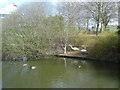
Nesting swans at County Hall
Next to the main entrance, this pair have a nest with eight eggs and seem quite content despite the busy situation.
Image: © Trevor Rickard
Taken: 8 Apr 2008
0.06 miles
6
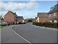
Dalziel Drive, Worcester
A long and serpentine road within a new housing development.
Image: © Chris Allen
Taken: 15 Mar 2021
0.08 miles
7
County Hall, Worcester
County Hall was built in the 1970s when the counties of Herefordshire and Worcestershire were merged into one. The two counties have since regained their independence and the building is now the headquarters of Worcestershire County Council.
Image: © Philip Halling
Taken: 27 May 2010
0.08 miles
8
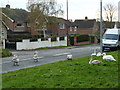
Roadside swans
Parents and cygnets near County Hall, Worcester. Not a sight you see everyday. In reality they were probably less than 100 yards from a suitable body of water.
Image: © Chris Allen
Taken: 14 Nov 2010
0.09 miles
9
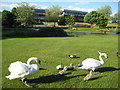
Swans at County Hall
Swans and cygnets with County Hall, the headquarters of Worcestershire County Council in the background.
Image: © Philip Halling
Taken: 27 May 2010
0.09 miles
10
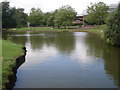
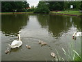
Large pond at County Hall
Viewed from near the site main entrance with the Worcester County Council offices behind the pond.
Image: © Trevor Rickard
Taken: 1 Jul 2007
0.09 miles