IMAGES TAKEN NEAR TO
Sobraon Crescent, WORCESTER, WR5 2GL
Introduction
This page details the photographs taken nearby to Sobraon Crescent, WR5 2GL by members of the Geograph project.
The Geograph project started in 2005 with the aim of publishing, organising and preserving representative images for every square kilometre of Great Britain, Ireland and the Isle of Man.

There are currently over 7.5m images from over14,400 individuals and you can help contribute to the project by visiting https://www.geograph.org.uk
Image Map
Images are licensed for reuse under creativecommons.org/licenses/by-sa/2.0
Notes
- Clicking on the map will re-center to the selected point.
- The higher the marker number, the further away the image location is from the centre of the postcode.
Image Listing (66 Images Found)
Images are licensed for reuse under creativecommons.org/licenses/by-sa/2.0
Image
Details
Distance
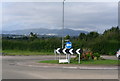
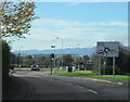
2
New roundabout at Norton
New roundabout at Norton on the junction of Norton Lane and Crookbarrow Road.
Image: © Philip Halling
Taken: 22 Mar 2014
0.04 miles
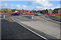
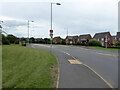
5
Crookbarrow Road Approaching Norton Road Island
Image: © Roy Hughes
Taken: 28 Oct 2017
0.04 miles
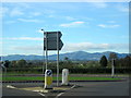
6
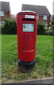
Elizabeth II postbox on Crookbarrow Road, Brockhill Village
Postbox No. WR5 162.
Image: © JThomas
Taken: 13 Aug 2021
0.05 miles
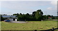
9
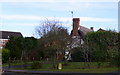
Ancient cottage beside the houses of Norton development
This cottage must predate the development by the army of the barracks.
Image: © Andrew Darge
Taken: 6 Jan 2008
0.05 miles
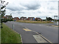
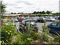
10
Crookbarrow Road, Norton, Worcestershire
Image: © Chris Allen
Taken: 9 Aug 2021
0.06 miles