IMAGES TAKEN NEAR TO
Woolhope Road, WORCESTER, WR5 2AS
Introduction
This page details the photographs taken nearby to Woolhope Road, WR5 2AS by members of the Geograph project.
The Geograph project started in 2005 with the aim of publishing, organising and preserving representative images for every square kilometre of Great Britain, Ireland and the Isle of Man.

There are currently over 7.5m images from over14,400 individuals and you can help contribute to the project by visiting https://www.geograph.org.uk
Image Map
Images are licensed for reuse under creativecommons.org/licenses/by-sa/2.0
Notes
- Clicking on the map will re-center to the selected point.
- The higher the marker number, the further away the image location is from the centre of the postcode.
Image Listing (732 Images Found)
Images are licensed for reuse under creativecommons.org/licenses/by-sa/2.0
Image
Details
Distance
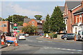
1
New house under construction, Bath Road
Image: © Oast House Archive
Taken: 14 Sep 2014
0.04 miles
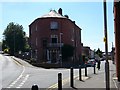
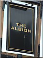
3
The Albion pub, Diglis Road
The pub occupies a triangular site between Diglis Road and Bath Road.
Image: © Stephen Craven
Taken: 7 Feb 2015
0.05 miles
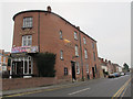
4
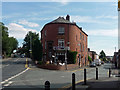
The Albion, Bath Road, Worcester
The pub, dated c1840, rounds the corner with Diglis Road.
Image: © Stephen Richards
Taken: 17 Jul 2014
0.05 miles
7
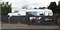
Former Bristol Street Motors car sales
The former Bristol Street Motors car sales on Bath Road in Worcester. Since this picture was taken this site has been redeveloped, the buildings demolished and a building of apartments has been built here, the cathedral tower now hidden by the modern building. The white building on the right is still standing fifteen years later.
Image: © Philip Halling
Taken: Unknown
0.07 miles
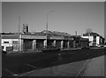
8
Bredon Hill viewed from Worcester Cathedral
Bredon Hill viewed from the top of the tower of Worcester Cathedral. The housing in the foreground is on Bath Road and the Battenhall area, a little more distant is the 1980s St Peter's housing development.
Image: © Philip Halling
Taken: 22 Aug 2014
0.07 miles
9

Airora Tansells vehicle repair shop, Diglis Road, Worcester
The building in the right background is a former flour mill converted to apartments.
Image: © Chris Allen
Taken: 1 Sep 2021
0.07 miles
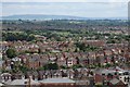
10
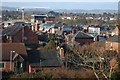
Sidbury, Worcester
View of the rooftops of Sidbury, Worcester, from Fort Royal Hill.
Image: © Philip Halling
Taken: 27 Feb 2008
0.08 miles