IMAGES TAKEN NEAR TO
Liverpool Road, WORCESTER, WR5 1QW
Introduction
This page details the photographs taken nearby to Liverpool Road, WR5 1QW by members of the Geograph project.
The Geograph project started in 2005 with the aim of publishing, organising and preserving representative images for every square kilometre of Great Britain, Ireland and the Isle of Man.

There are currently over 7.5m images from over14,400 individuals and you can help contribute to the project by visiting https://www.geograph.org.uk
Image Map
Images are licensed for reuse under creativecommons.org/licenses/by-sa/2.0
Notes
- Clicking on the map will re-center to the selected point.
- The higher the marker number, the further away the image location is from the centre of the postcode.
Image Listing (51 Images Found)
Images are licensed for reuse under creativecommons.org/licenses/by-sa/2.0
Image
Details
Distance
1
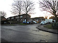
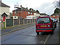
Lincoln Green, Ronkswood
Seen across Chelmsford drive on the large Ronkswood Estate. This is warden controlled sheltered housing.
Image: © Chris Allen
Taken: 20 Dec 2022
0.04 miles
2
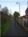
Public footpath, Ronkswood, Worcester
Leading from Chelmsford Drive towards the community centre.
Image: © Chris Allen
Taken: 20 Dec 2022
0.05 miles
3
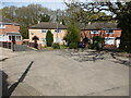
Guildford Close, Ronkswood, Worcester
This large estate has streets named after cities and towns with a cathedral.
Image: © Chris Allen
Taken: 24 Apr 2021
0.05 miles
4
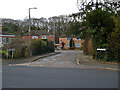
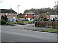
Guildford Close, Ronkswood estate, Worcester
Seen from Liverpool Road. This is a large estate of social housing with the streets apparently named after places with cathedrals. Guildford is one of those towns that has a cathedral but lacks city status. Perry Wood is seen beyond the houses.
Image: © Chris Allen
Taken: 11 Mar 2021
0.05 miles
5
Wakefield Close, Ronkswood estate, Worcester
From the junction with Liverpool Road.
Image: © Chris Allen
Taken: 11 Mar 2021
0.05 miles
6
Oxford Close from Liverpool Road, Ronkswood
A large council housing estate.
Image: © Chris Allen
Taken: 11 Mar 2021
0.05 miles
7
Salisbury Close from Chelmsford Drive
In the Ronkswood estate of council housing.
Image: © Chris Allen
Taken: 15 Mar 2021
0.07 miles
8
Salisbury Close and a typo!
On the Ronkswood estate in Worcester and seen Chelmsford Drive. The name board on the right states Salisbury but the one on the left states Sailsbury.
Image: © Chris Allen
Taken: 20 Dec 2022
0.07 miles
9
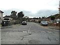
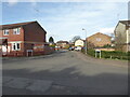
Liverpool Road, Ronkswood
Seen from the junction with Canterbury Road. Liverpool Road and Canterbury Road are the two main roads in the estate that most others seem to link up with. Ronkswood is a large estate of social housing - one of several in Worcester.
Image: © Chris Allen
Taken: 6 Dec 2022
0.07 miles
10
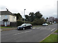
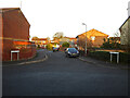
Liverpool Road, Ronkswood, Worcester
At the junction with Canterbury Road. Part of the Ronkswood estate of social housing with streets named after places with cathedrals.
Image: © Chris Allen
Taken: 11 Mar 2021
0.08 miles