IMAGES TAKEN NEAR TO
Skiddaw Close, WORCESTER, WR4 9HU
Introduction
This page details the photographs taken nearby to Skiddaw Close, WR4 9HU by members of the Geograph project.
The Geograph project started in 2005 with the aim of publishing, organising and preserving representative images for every square kilometre of Great Britain, Ireland and the Isle of Man.

There are currently over 7.5m images from over14,400 individuals and you can help contribute to the project by visiting https://www.geograph.org.uk
Image Map
Images are licensed for reuse under creativecommons.org/licenses/by-sa/2.0
Notes
- Clicking on the map will re-center to the selected point.
- The higher the marker number, the further away the image location is from the centre of the postcode.
Image Listing (82 Images Found)
Images are licensed for reuse under creativecommons.org/licenses/by-sa/2.0
Image
Details
Distance
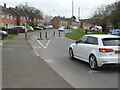
1
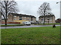
Apartment refurbishment, Worcester
These blocks are more or less at the junction of Tolladine Road and Windermere Drive in the large Warndon council housing estate.
Image: © Chris Allen
Taken: 20 Feb 2021
0.04 miles
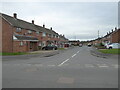
2
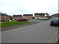
Patterdale Drive, Warndon, Worcester
More of this large council housing estate with streets named after places in the Lake District.
Image: © Chris Allen
Taken: 23 Feb 2021
0.05 miles
3
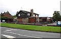
The Prince of Wales (1), Windermere Drive, Warndon, Worcester
Located on the corner of Windermere Drive and Buttermere Drive, this local community pub is a Marston's house, although it trades as a Banks's house, which is part of Marston's. The pub offers various games including skittles, darts & crib.
Image
Image: © P L Chadwick
Taken: 6 Sep 2014
0.05 miles
4

The Prince of Wales (2) - sign, Windermere Drive, Warndon, Worcester
The sign is on a post in the car park. The sign is of a type long used by Banks's showing their golden lion. As more of their pubs are either sold off, or rebranded as Marston's, this design of sign is fast disappearing. Hopefully some will remain.
The Prince of Wales is quite a popular name for public houses. This is a relatively modern pub, probably dating from the 1960's or 1970's. The area around here was developed in the 1960's, so it is quite possible that the name was given because of the Investiture of Prince Charles as Prince of Wales in 1969. It needs to be stressed this a guess not a statement of fact.
Image
Image: © P L Chadwick
Taken: 6 Sep 2014
0.05 miles
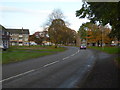
5
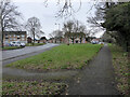
Tolladine Road, Worcester
In the Warndon estate of social housing. Tolladine road has a dogleg here in front of the central block of flats, sweeping from left to right to terminate as a no through road. To the left of the central block is Windermere Drive that is a through route to Blackpole.
Image: © Chris Allen
Taken: 20 Feb 2021
0.06 miles
6
Windermere Drive, Warndon
With traffic calming measures. Within a large council housing estate.
Image: © Chris Allen
Taken: 6 Mar 2021
0.07 miles
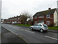
7
Tolladine Road, Worcester
Older social housing in Worcester. The streets off to the left all have Lake District names. Out of sight to the right is Long Meadow, one of the more recent private developments of Warndon Villages.
Image: © Chris Allen
Taken: 4 Nov 2019
0.08 miles
8
Penrith Close from Windermere Drive, Warndon
In a large housing estate with streets named after places in the Lake District.
Image: © Chris Allen
Taken: 6 Mar 2021
0.08 miles
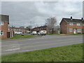
9
Patterdale Drive, Warndon
A large council estate with streets named after places in the Lake District.
Image: © Chris Allen
Taken: 20 Feb 2021
0.09 miles
10
Bowness Drive from Borrowdale Drive, Warndon, Worcester
A large council housing estate with streets named after places in the Lake District.
Image: © Chris Allen
Taken: 23 Feb 2021
0.10 miles