IMAGES TAKEN NEAR TO
Kenwood Avenue, WORCESTER, WR4 9BL
Introduction
This page details the photographs taken nearby to Kenwood Avenue, WR4 9BL by members of the Geograph project.
The Geograph project started in 2005 with the aim of publishing, organising and preserving representative images for every square kilometre of Great Britain, Ireland and the Isle of Man.

There are currently over 7.5m images from over14,400 individuals and you can help contribute to the project by visiting https://www.geograph.org.uk
Image Map
Images are licensed for reuse under creativecommons.org/licenses/by-sa/2.0
Notes
- Clicking on the map will re-center to the selected point.
- The higher the marker number, the further away the image location is from the centre of the postcode.
Image Listing (64 Images Found)
Images are licensed for reuse under creativecommons.org/licenses/by-sa/2.0
Image
Details
Distance
1
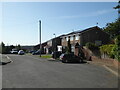
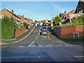
Kenwood Avenue, Worcester
This avenue leads up hill to this, its highest point. Behind the photographer is the path linking Elbury Park (or Elbury Mount) to Gorse Hill.
Image: © Chris Allen
Taken: 18 Sep 2019
0.05 miles
2
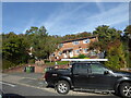
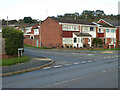
Cheviot Close, Worcester
At the top of Kenwood Avenue. The vehicle is hiding the street name.
Image: © Chris Allen
Taken: 25 Oct 2022
0.05 miles
3
Mendip Close
Off Kenwood Avenue, Worcester.
Image: © Chris Allen
Taken: 25 Oct 2022
0.07 miles
4
Elbury Park
Also referred to as Elbury Mount or Elbury Hill this is one of the highest spots in the City of Worcester and home to three service reservoirs owned by Severn Trent Water. A CCTV camera is visible.
Image: © Chris Allen
Taken: 23 Aug 2019
0.08 miles
5
Lutterworth Close, Worcester
Off Tolladine Road.
Image: © Chris Allen
Taken: 1 Dec 2020
0.08 miles
6
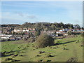
Elbury Mount seen from Leopard Hill
Elbury Mount and Leopard Hill are the highest points in Worcester at 98m. In the foreground is Ronkswood Hill Meadows Local Nature Reserve. This includes some noticeable ridge and furrow agricultural remains that are really obvious on foot. The area is grazed by cows in summer.
Image: © Chris Allen
Taken: 23 Jan 2019
0.09 miles
7
Chiltern Close, Worcester
Off Kenwood Avenue that is off Tolladine Road.
Image: © Chris Allen
Taken: 25 Oct 2022
0.09 miles
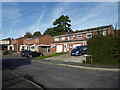
8
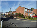
Kenwood Avenue, Worcester
Seen from Tolladine Road.
Image: © Chris Allen
Taken: 3 Nov 2021
0.10 miles
9
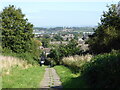
Path from Troutbeck Drive to Kenwood Avenue
This is heading up hill and is close to one of the highest points in Worcester. Kenwood Avenue is in the direction behind the photographer.
Image: © Chris Allen
Taken: 18 Sep 2019
0.10 miles
10

Steps in Elbury Park, Worcester
Looking down the steps that lead up to the service reservoirs that are on one of Worcester's highest points. At the bottom is the access road to the reservoirs.
Image: © Chris Allen
Taken: 2 May 2021
0.11 miles