IMAGES TAKEN NEAR TO
Tolladine Road, WORCESTER, WR4 9AR
Introduction
This page details the photographs taken nearby to Tolladine Road, WR4 9AR by members of the Geograph project.
The Geograph project started in 2005 with the aim of publishing, organising and preserving representative images for every square kilometre of Great Britain, Ireland and the Isle of Man.

There are currently over 7.5m images from over14,400 individuals and you can help contribute to the project by visiting https://www.geograph.org.uk
Image Map
Images are licensed for reuse under creativecommons.org/licenses/by-sa/2.0
Notes
- Clicking on the map will re-center to the selected point.
- The higher the marker number, the further away the image location is from the centre of the postcode.
Image Listing (48 Images Found)
Images are licensed for reuse under creativecommons.org/licenses/by-sa/2.0
Image
Details
Distance
1
Maple Avenue, Worcester
This has the appearance of current/former council housing.
Image: © Chris Allen
Taken: 3 Nov 2021
0.03 miles
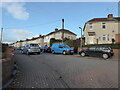
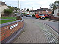
2
Cherwell Close, Worcester
From Tolladine Road.
Image: © Chris Allen
Taken: 3 Nov 2021
0.06 miles
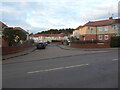
3
The junction of Teme Road and Avon Road, Tolladine
An area of apparent social housing not far from Worcester city centre. Unfortunately my shot of Avon road to the right is blurred due to camera motion.
Image: © Chris Allen
Taken: 27 Dec 2019
0.06 miles
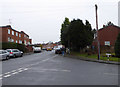
4
Portefields Road, Worcester
Seen across Tolladine Road and having the appearance of a council housing estate. Gorse Hill is seen behind and is wooded.
Image: © Chris Allen
Taken: 3 Nov 2021
0.07 miles
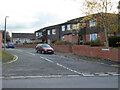
5
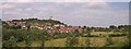
Ronkswood
An open green space in Worcester.
Image: © Bob Embleton
Taken: 20 Jun 2005
0.08 miles
6
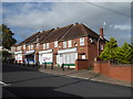
Closed shops, Rose Avenue, Tolladine
In 2014 these four shops were open - Image Now only the fish and chips shop is open. On the opposite side of the avenue were a further three shops in four former units. Now only one of these is open and its integral post office part has closed permanently. I didn't photograph those on the opposite side due to bad lighting.
Image: © Chris Allen
Taken: 26 Sep 2019
0.08 miles
7
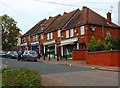
Another four shop units in Rose Avenue, Tolladine, Worcester
The four shops on this side of Rose Avenue are occupied by the Italian Job (a takeaway), Rose Avenue Fryer (fish & chip shop), M & R General Stores, and Worcester Angling Centre.
See also:- Image
Image: © P L Chadwick
Taken: 6 Sep 2014
0.08 miles
8
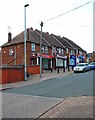
Four shop units in Rose Avenue, Tolladine, Worcester
Just off Tolladine Road, there are eight shop units in Rose Avenue serving the large Tolladine housing estate. On this side of Rose Avenue are half the units. These are occupied by a bookmakers, a butchers and two units are used by a convenience store which has an off-licence and includes a post office.
See also:- Image
Image: © P L Chadwick
Taken: 6 Sep 2014
0.10 miles
9
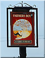
Farmers Boy (2) - sign, Tolladine Road, Tolladine, Worcester
The pub building, which is now shared with an Indian restaurant, appears to be older than the surrounding housing, so probably when it was built it was surrounded by farmland, hence the name.
According to the sign, which is on a post in the car park, the pub is part of the Enterprise Inns chain. The other side of the sign is actually a sign for the adjoining restaurant.
Image
Image: © P L Chadwick
Taken: 6 Sep 2014
0.11 miles
10
Birch Avenue, Worcester
Seen from Holly Mount. The housing has the appearance of council houses.
Image: © Chris Allen
Taken: 3 Nov 2021
0.12 miles