IMAGES TAKEN NEAR TO
Vicar Street, WORCESTER, WR3 8EU
Introduction
This page details the photographs taken nearby to Vicar Street, WR3 8EU by members of the Geograph project.
The Geograph project started in 2005 with the aim of publishing, organising and preserving representative images for every square kilometre of Great Britain, Ireland and the Isle of Man.

There are currently over 7.5m images from over14,400 individuals and you can help contribute to the project by visiting https://www.geograph.org.uk
Image Map
Images are licensed for reuse under creativecommons.org/licenses/by-sa/2.0
Notes
- Clicking on the map will re-center to the selected point.
- The higher the marker number, the further away the image location is from the centre of the postcode.
Image Listing (81 Images Found)
Images are licensed for reuse under creativecommons.org/licenses/by-sa/2.0
Image
Details
Distance
2
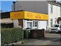
Chinese takeaway, Vicar Street, Worcester
Image: © Chris Allen
Taken: 12 Feb 2024
0.01 miles
3
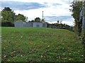
Covered reservoir seen from Railway Walk, Worcester
The reservoir is one of Severn Trent's. Railway Walk is a public footpath that is above the railway and the site of Worcester's former locomotive shed. Many years ago it afforded spectacular views and was popular with earlier generations of railway photographer. It is now so overgrown that you can no longer see the railway.
Image: © Chris Allen
Taken: 3 Nov 2021
0.04 miles
4
Service Reservoir by Vicar Street, Worcester
Severn Trent Water covered reservoir.
Image: © Chris Allen
Taken: 3 Nov 2021
0.04 miles
6

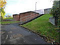
Scout hut on Rainbow Rise, Worcester
Home to the 3rd Worcester scout troop. This is well hidden. Architecturally it seems typical of other scout 'huts' I have seen.
Image: © Chris Allen
Taken: 3 Nov 2021
0.04 miles
7
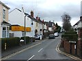
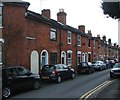
Albany Road, Worcester
Older housing stock seen from Vicar Street.
Image: © Chris Allen
Taken: 3 Nov 2021
0.04 miles
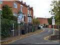
8
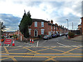
Road junction on Rainbow Hill, Worcester
Rainbow Hill is the main road from left to right. Opposite the photographer are Lansdowne Road on the left and Belmont Street on the right. These contain older housing stock.
Image: © Chris Allen
Taken: 3 Nov 2021
0.04 miles
9
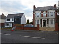
Old and new houses on Rainbow Hill, Worcester
An interesting juxtaposition of styles - Victorian vs 21st century. Different people will have differing preferences for these.
Image: © Chris Allen
Taken: 3 Nov 2021
0.04 miles
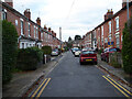
10
Mayfield Road, Worcester
Seen from Rainbow Hill
Image: © Chris Allen
Taken: 3 Nov 2021
0.06 miles