IMAGES TAKEN NEAR TO
Wordsworth Avenue, WORCESTER, WR3 8DN
Introduction
This page details the photographs taken nearby to Wordsworth Avenue, WR3 8DN by members of the Geograph project.
The Geograph project started in 2005 with the aim of publishing, organising and preserving representative images for every square kilometre of Great Britain, Ireland and the Isle of Man.

There are currently over 7.5m images from over14,400 individuals and you can help contribute to the project by visiting https://www.geograph.org.uk
Image Map
Images are licensed for reuse under creativecommons.org/licenses/by-sa/2.0
Notes
- Clicking on the map will re-center to the selected point.
- The higher the marker number, the further away the image location is from the centre of the postcode.
Image Listing (70 Images Found)
Images are licensed for reuse under creativecommons.org/licenses/by-sa/2.0
Image
Details
Distance
1
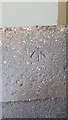
Ordnance Survey Rivet
Rivet and arrow located on Birmingham to Worcester canal bank very near to bridge number 14. These rivets and marks were used by Ordnance Survey for mapping purposes.
Image: © V1ncenze
Taken: 23 Jan 2020
0.03 miles
2

Bridge 14, Worcester and Birmingham Canal
Looking north towards Bilford Locks.
Image: © Pierre Terre
Taken: 15 May 2009
0.04 miles
3

Somebody in Wordsworth Avenue likes the canal
Back garden alongside the Worcester and Birmingham Canal, west of Bridge 14.
Image: © Christine Johnstone
Taken: 6 Sep 2012
0.04 miles
4

Canal Bridge, Worcester
This is bridge number 14 located on the Worcester to Birmingham canal.
Image: © V1ncenze
Taken: 23 Jan 2020
0.04 miles
5
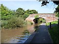
Bridge 14, from the west
The Worcester and Birmingham Canal's towpath is also the route of the Monarch's Way [from Blackpole to Diglis].
Image: © Christine Johnstone
Taken: 6 Sep 2012
0.04 miles
6

Astwood Cemetery Bridge in Worcester
Astwood Cemetery Bridge (No 14) is a former farmer's accommodation bridge. Housing estates are now on both sides of the canal and the bridge is not open to traffic. Beyond the bridge is Bilford Bottom Lock.
Image: © Roger D Kidd
Taken: 21 Aug 2010
0.04 miles
7

Bridge 14, Worcester and Birmingham Canal
Image: © Philip Halling
Taken: 20 Apr 2013
0.04 miles

9

Worcester and Birmingham Canal
Looking north from Gregory's Mill Top Lock.
Image: © Pierre Terre
Taken: 16 May 2009
0.05 miles
10

Worcester and Birmingham Canal, near Astwood
The Worcester and Birmingham Canal, near Astwood, in the northern suburbs of Worcester.
Image: © Philip Halling
Taken: 20 Apr 2013
0.05 miles