IMAGES TAKEN NEAR TO
Hardy Court, WORCESTER, WR3 8AT
Introduction
This page details the photographs taken nearby to Hardy Court, WR3 8AT by members of the Geograph project.
The Geograph project started in 2005 with the aim of publishing, organising and preserving representative images for every square kilometre of Great Britain, Ireland and the Isle of Man.

There are currently over 7.5m images from over14,400 individuals and you can help contribute to the project by visiting https://www.geograph.org.uk
Image Map
Images are licensed for reuse under creativecommons.org/licenses/by-sa/2.0
Notes
- Clicking on the map will re-center to the selected point.
- The higher the marker number, the further away the image location is from the centre of the postcode.
Image Listing (74 Images Found)
Images are licensed for reuse under creativecommons.org/licenses/by-sa/2.0
Image
Details
Distance
1
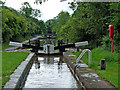
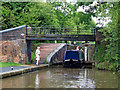
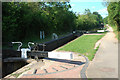
Gregory's Mill Locks in Worcester
The two Gregory's Mill Locks (Nos 5 and 6) in Worcester lower (or raise) the level by seven feet (2·1 metres) each.
Image: © Roger D Kidd
Taken: 21 Aug 2010
0.06 miles
2
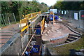
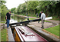
Lock repairs on the Worcester and Birmingham Canal
Image: © David Martin
Taken: 19 Nov 2016
0.07 miles
3
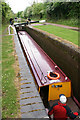
Gregory's Mill Bottom Lock
Filling up lock on the Worcester and Birmingham Canal.
Image: © Pierre Terre
Taken: 15 May 2009
0.07 miles
4
Gregory Mill lock, Worcester
This lock is located on the Worcester to Birmingham canal.
Image: © V1ncenze
Taken: 23 Jan 2020
0.07 miles
5
Gregory's Mill Bottom Lock
Heading up the Worcester and Birmingham Canal.
Image: © Pierre Terre
Taken: 15 May 2009
0.07 miles
6
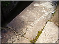
Benchmark on Gregory Mill Lock
This benchmark was established in 1849 during the First primary levelling of England & Wales, and was levelled with a height of 78.6900 feet [23.9847 metres] above mean sea level (Liverpool datum). It was included on the Manchester to Gloucester (Branch Levelling to Public Buildings, &c. in the City of Worcester and its environs) levelling line. The surveyor's description was "No. 15. Gregory Mill Lock, on Worcester and Birmingham Canal. Bolt in West side and South end ; level with surface." (Public Abstract p.40) The original bolt has been replaced by a more modern rivet. 2m SW of bottom gate, NW side of canal (opposite towpath), about 10m NE of footbridge.
Image: © Shantavira
Taken: 1 Sep 2014
0.08 miles
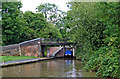
7
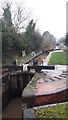
Gregory's Mill Bottom Lock near Barbourne, Worceste
Gregory's Mill Bottom Lock is No 5 on the Worcester and Birmingham Canal. Its companion lock is about two hundred metres further ahead. Each lock provides a rise of seven feet (2·1 metres). Bridge No 13 is for pedestrians and cyclists only now.
Image: © Roger D Kidd
Taken: 21 Aug 2010
0.08 miles
8
Gregory's Mill Bottom Lock near Barbourne, Worcester
Gregory's Mill Bottom Lock is No 5 on the Worcester and Birmingham Canal. Its companion lock is about two hundred metres further ahead. Each lock provides a rise of seven feet (2·1 metres). Bridge No 13 used for pedestrians and cyclists now. The former brickworks (off to the right) is now (2018) redeveloped as a housing estate.
Image: © Roger D Kidd
Taken: 21 Aug 2010
0.08 miles
10
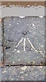
Ordnance Survey Rivet
This rivet is located at Gregory Mill lock on the Worcester to Birmingham canal. These marks were used by Ordnance Survey for mapping purposes.
Image: © V1ncenze
Taken: 23 Jan 2020
0.08 miles