IMAGES TAKEN NEAR TO
Lamberton Close, WORCESTER, WR2 6ND
Introduction
This page details the photographs taken nearby to Lamberton Close, WR2 6ND by members of the Geograph project.
The Geograph project started in 2005 with the aim of publishing, organising and preserving representative images for every square kilometre of Great Britain, Ireland and the Isle of Man.

There are currently over 7.5m images from over14,400 individuals and you can help contribute to the project by visiting https://www.geograph.org.uk
Image Map
Images are licensed for reuse under creativecommons.org/licenses/by-sa/2.0
Notes
- Clicking on the map will re-center to the selected point.
- The higher the marker number, the further away the image location is from the centre of the postcode.
Image Listing (46 Images Found)
Images are licensed for reuse under creativecommons.org/licenses/by-sa/2.0
Image
Details
Distance
1
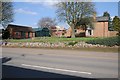
House and sheds in Hallow
This house and its shed beside the A443 are surrounded by a building site.
Image: © Philip Halling
Taken: 14 Apr 2018
0.03 miles
2
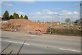
Building site in Hallow
Building site immediately to the north of A.E Clegg Ltd car sales in Hallow.
Image: © Philip Halling
Taken: 14 Apr 2018
0.03 miles
3

Vauxhall car sales at Hallow
Vauxhall car sales at A.E Clegg Ltd in Hallow. The land opposite is just about to be built on.
Image: © Philip Halling
Taken: 14 Apr 2018
0.05 miles
4
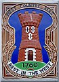
The Royal Oak (4) - West Country Ales plaque, Main Road, Hallow
An interesting detail on this pub, is this West Country Ales plaque. The ceramic plaque is affixed to the front wall of the pub. It was first used by the Gloucestershire brewers, West Country Breweries, who were an amalgamation of others, two of whom commenced brewing in 1760. The plaques were placed by West Country Breweries on their pubs between 1958 and 1963, when Whitbreads took them over. Whitbreads continued to use the castle logo and to install these plaques, for a few years after the takeover until about 1967. There are still quite a few around, with some variation of colour, and in two sizes.
Other photos:- Image
Image: © P L Chadwick
Taken: 27 Dec 2011
0.05 miles
5

The Royal Oak (3) - sign, Main Road, Hallow
There are many pubs in England named the Royal Oak, to celebrate the restoration of the monarchy in 1660. The significance of the oak being that, before the restoration, the future King Charles II spent most of one day, hiding in an oak tree from Oliver Cromwell's Parliamentarian troops. His birthday of May 29th was still celebrated by many people up to the end of the 19th century. Therefore many pubs continued to be given the name of Royal Oak, even when they were opened a hundred or two hundred years later. Today, for better or worse, the day has lost its significance, probably because the 29th May ceased to be a public holiday some time in the 1850's.
Other photos:- Image
Image: © P L Chadwick
Taken: 27 Dec 2011
0.05 miles
6

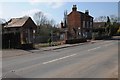
The Royal Oak (2), Main Road, Hallow
The pub was closed and to let when photographed in late December 2011.
Other photos:- Image
Image: © P L Chadwick
Taken: 27 Dec 2011
0.05 miles
7

The Royal Oak (1), Main Road, Hallow
One of the two public houses in Hallow, the Royal Oak was closed when photographed in December 2011. It is owned by pub chain Enterprise Inns, and had a "to let" sign outside.
Image
Image
Image
Image: © P L Chadwick
Taken: 27 Dec 2011
0.05 miles
8
Redevelopment in Hallow
An empty house and site opposite Glegg's car sales in Hallow awaiting redevelopment.
Image: © Philip Halling
Taken: 14 Apr 2018
0.05 miles
9

A E Clegg Ltd, Main Road, Hallow
A family run car dealer established in 1929. They specialise in new and used Chevrolet, used Vauxhall and authorised repairs & services of these makes as well as Saab. Also repairs and services for other makes of car and does MOT testing.
Image: © P L Chadwick
Taken: 27 Dec 2011
0.05 miles
10
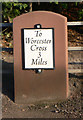
Replica Milestone by the A443, Hallow village
Metal plate attached to stone post by the A443, in parish of Hallow (MALVERN HILLS District), opposite Archbell Cottages, just South of Pinchfield Gardens, against metal rail fence by drive to Jessamine, on Northeast side of road. Worcester Cross iron plate - original erected by the Worcester turnpike trust in the 19th century.
Inscription reads:-
To
Worcester
Cross
3
Miles
Milestone Society National ID: WO_WOGW03
Image: © J Higgins
Taken: 20 Dec 2014
0.06 miles