IMAGES TAKEN NEAR TO
Main Road, WORCESTER, WR2 6LW
Introduction
This page details the photographs taken nearby to Main Road, WR2 6LW by members of the Geograph project.
The Geograph project started in 2005 with the aim of publishing, organising and preserving representative images for every square kilometre of Great Britain, Ireland and the Isle of Man.

There are currently over 7.5m images from over14,400 individuals and you can help contribute to the project by visiting https://www.geograph.org.uk
Image Map
Images are licensed for reuse under creativecommons.org/licenses/by-sa/2.0
Notes
- Clicking on the map will re-center to the selected point.
- The higher the marker number, the further away the image location is from the centre of the postcode.
Image Listing (7 Images Found)
Images are licensed for reuse under creativecommons.org/licenses/by-sa/2.0
Image
Details
Distance
1
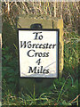
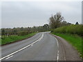
Old Milestone by the A443, Grimley parish
Metal plate attached to stone post by the A443, in parish of GRIMLEY (MALVERN HILLS District), opposite drive to park, back of a wide verge by hedge, on East side of road. Worcester Cross iron plate, erected by the Worcester turnpike trust in the 19th century.
Inscription reads:-
To
Worcester
Cross
4
Miles
Milestone Society National ID: WO_WOGW04.
Image: © P Willis
Taken: 20 Dec 2014
0.15 miles
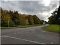
3
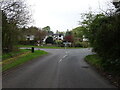
A443 - Sinton Green crossroads
Seen from the road to Grimley.
Image: © Peter Whatley
Taken: 19 Jun 2008
0.19 miles