IMAGES TAKEN NEAR TO
Hallow Road, WORCESTER, WR2 6DD
Introduction
This page details the photographs taken nearby to Hallow Road, WR2 6DD by members of the Geograph project.
The Geograph project started in 2005 with the aim of publishing, organising and preserving representative images for every square kilometre of Great Britain, Ireland and the Isle of Man.

There are currently over 7.5m images from over14,400 individuals and you can help contribute to the project by visiting https://www.geograph.org.uk
Image Map
Images are licensed for reuse under creativecommons.org/licenses/by-sa/2.0
Notes
- Clicking on the map will re-center to the selected point.
- The higher the marker number, the further away the image location is from the centre of the postcode.
Image Listing (27 Images Found)
Images are licensed for reuse under creativecommons.org/licenses/by-sa/2.0
Image
Details
Distance
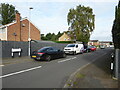
1
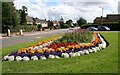
Floral Display, Hallow Road,/Monarch Drive Junction
Looking along Hallow Road towards Worcester.
Image: © Bob Embleton
Taken: 12 Aug 2007
0.03 miles
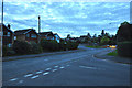
2
Little Eastbury : Hallow Road A443
Looking towards the road junction with Monarch Drive in Worcester.
Image: © Lewis Clarke
Taken: 4 May 2014
0.04 miles
3
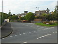
Monarch Drive, Worcester
From Hallow Road.
Image: © Chris Allen
Taken: 16 Oct 2021
0.04 miles
4
Hallow Road / Monarch Drive junction, Worcester
Image: © Mat Fascione
Taken: 27 Jul 2013
0.04 miles
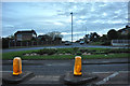
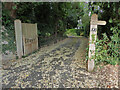
5
Riverview Close
Off Hallow Road, Worcester.
Image: © Chris Allen
Taken: 16 Oct 2021
0.04 miles
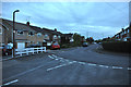
6
Worcester : Hallow Road A443
Looking along Hallow Road from the junction with Riverview Close.
Image: © Lewis Clarke
Taken: 4 May 2014
0.05 miles
7
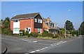
Entrance to Hallow Bank, Worcester
Hallow Bank is a Grade II Listed house but this is the only view from a public location.
Image: © Chris Allen
Taken: 16 Oct 2021
0.06 miles
8
Worcester : Riverview Close
A small residential road in the Worcester suburbs.
Image: © Lewis Clarke
Taken: 4 May 2014
0.06 miles
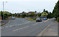
9
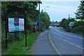
Worcester : Hallow Road A443
Looking along Hallow Road as it heads into Worcester. A sign and information is on the pavement to the left.
Image: © Lewis Clarke
Taken: 4 May 2014
0.06 miles
10
Bramley Avenue, Worcester
Residential area, photographed at the junction of Monarch Drive and Bramley Avenue.
Image: © Mary and Angus Hogg
Taken: 27 Sep 2008
0.08 miles