IMAGES TAKEN NEAR TO
Fairfax Way, WORCESTER, WR2 5TZ
Introduction
This page details the photographs taken nearby to Fairfax Way, WR2 5TZ by members of the Geograph project.
The Geograph project started in 2005 with the aim of publishing, organising and preserving representative images for every square kilometre of Great Britain, Ireland and the Isle of Man.

There are currently over 7.5m images from over14,400 individuals and you can help contribute to the project by visiting https://www.geograph.org.uk
Image Map
Images are licensed for reuse under creativecommons.org/licenses/by-sa/2.0
Notes
- Clicking on the map will re-center to the selected point.
- The higher the marker number, the further away the image location is from the centre of the postcode.
Image Listing (29 Images Found)
Images are licensed for reuse under creativecommons.org/licenses/by-sa/2.0
Image
Details
Distance
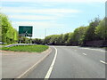
1
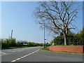
The new Bransford Road
Re-aligned to meet the A4440 Worcester by-pass up ahead.
Image: © Jonathan Billinger
Taken: 23 Apr 2010
0.06 miles
3
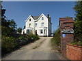
Laugherne Grange bed and breakfast, Worcester
On Bransford Road inside the bypass road.
Image: © Chris Allen
Taken: 13 Sep 2020
0.15 miles
4
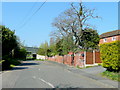
The old Bransford Road
Looking west, away from Worcester and towards Hereford.
The A4440 Worcester by-pass crosses the road up ahead.
Image: © Jonathan Billinger
Taken: 23 Apr 2010
0.17 miles
5
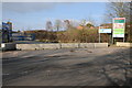
Former Kays site, St John's
This land used to be the site of a huge Kays distribution centre, the site on the right reads 'Coming soon Persimmon Heights'. The land is to be redeveloped for housing.
Image: © Philip Halling
Taken: 1 Mar 2012
0.17 miles
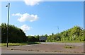
6
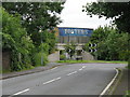
New roads for old
Forty-four tonnes of Foster's lager is carried on the Rushwick bypass over the course of the old Bransford Road, now blocked off to encourage vehicles to use the bypass.
Image: © Peter Whatley
Taken: 12 Jun 2008
0.19 miles
7
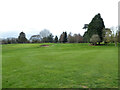
Worcester Golf and Country Club from the public footpath
A bunker in the distance.
Image: © Chris Allen
Taken: 27 Mar 2021
0.19 miles
9
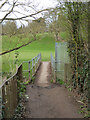
Public footpath crossing the Laughern Brook
In Worcester Golf and Country Club
Image: © Chris Allen
Taken: 27 Mar 2021
0.22 miles
10
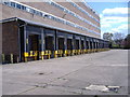
Kays Catalogue Warehouse
Kays catalogue warehouse-Bransford Road-lorry docking bays
Image: © James Pratt
Taken: 21 Apr 2010
0.22 miles