IMAGES TAKEN NEAR TO
Tudor Way, WORCESTER, WR2 5QY
Introduction
This page details the photographs taken nearby to Tudor Way, WR2 5QY by members of the Geograph project.
The Geograph project started in 2005 with the aim of publishing, organising and preserving representative images for every square kilometre of Great Britain, Ireland and the Isle of Man.

There are currently over 7.5m images from over14,400 individuals and you can help contribute to the project by visiting https://www.geograph.org.uk
Image Map
Images are licensed for reuse under creativecommons.org/licenses/by-sa/2.0
Notes
- Clicking on the map will re-center to the selected point.
- The higher the marker number, the further away the image location is from the centre of the postcode.
Image Listing (15 Images Found)
Images are licensed for reuse under creativecommons.org/licenses/by-sa/2.0
Image
Details
Distance
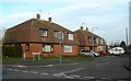
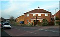
1
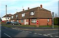
Tudor Way, Worcester
The junction of Tudor Way and Hawkins Close in a residential part of Worcester.
Image: © Mary and Angus Hogg
Taken: 31 Jan 2009
0.01 miles
2
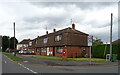
Houses on Tudor Way, Worcester
Showing position of Postbox No. WR2 181.
See Image] for postbox.
Image: © JThomas
Taken: 11 Aug 2021
0.03 miles
3
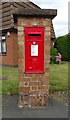
Elizabeth II postbox on Tudor Way, Worcester
Postbox No. WR2 181.
See Image] for context.
Image: © JThomas
Taken: 11 Aug 2021
0.03 miles
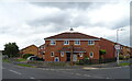
4
Howard Road, Dynes Green, Worcester
The furthest extent of this 1950's built local authority estate.
Image: © Jonathan Billinger
Taken: 27 Nov 2017
0.04 miles
5
Houses In Norfolk Close, Worcester
Viewed at the junction of Norfolk Close and Tudor Way.
Image: © Mary and Angus Hogg
Taken: 31 Jan 2009
0.06 miles
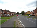
7
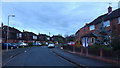
Houses on Tudor Way, Dines Green, Worcester
Image: © JThomas
Taken: 11 Aug 2021
0.10 miles
8
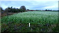
Cover crop at Temple Laugherne Farm
The unusual sight of a flowering crop at the end of November leads me to suspect that this is a green manure crop designed to aid fertility in an organic system.
Image: © Jonathan Billinger
Taken: 27 Nov 2017
0.12 miles
9
The Corner of Drake Avenue, Worcester
Houses at the northern junction of Drake Avenue and Tudor Way.
Image: © Mary and Angus Hogg
Taken: 31 Jan 2009
0.12 miles
10
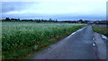
Farm road and footpath
Looking towards Temple Laugherne Farm which can be seen.
The unusual sight of a flowering crop at the end of November leads me to suspect that this is a green manure crop designed to aid fertility in an organic system.
This scene is on the edge of the City of Worcester just into the neighbouring authority, leading me to conclude that this is green belt.
Image: © Jonathan Billinger
Taken: 27 Nov 2017
0.13 miles