IMAGES TAKEN NEAR TO
King Stephens Mount, WORCESTER, WR2 5PL
Introduction
This page details the photographs taken nearby to King Stephens Mount, WR2 5PL by members of the Geograph project.
The Geograph project started in 2005 with the aim of publishing, organising and preserving representative images for every square kilometre of Great Britain, Ireland and the Isle of Man.

There are currently over 7.5m images from over14,400 individuals and you can help contribute to the project by visiting https://www.geograph.org.uk
Image Map
Images are licensed for reuse under creativecommons.org/licenses/by-sa/2.0
Notes
- Clicking on the map will re-center to the selected point.
- The higher the marker number, the further away the image location is from the centre of the postcode.
Image Listing (51 Images Found)
Images are licensed for reuse under creativecommons.org/licenses/by-sa/2.0
Image
Details
Distance
2
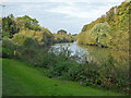
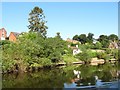
The River Severn at Worcester
A little bit upstream from the city centre. The racecourse is on the other side of the river and the cathedral can be seen through the trees in the distance.
Image: © Bill Boaden
Taken: 23 Feb 2018
0.04 miles
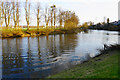
3
River Severn by Worcester racecourse, 1964
Looking downstream, with the racecourse on the left.
Image: © Robin Webster
Taken: 6 Apr 1964
0.04 miles
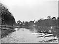
4
Boats moored on the west bank of the Severn
Seen from the back of a narrowboat heading upstream.
Image: © Christine Johnstone
Taken: 7 Sep 2012
0.04 miles
5
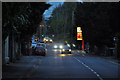
Worcester : Henwick Road A443
Looking along Henwick Road as it heads into the centre of Worcester.
Image: © Lewis Clarke
Taken: 4 May 2014
0.06 miles
6
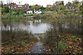
Path to a landing stage by the River Severn
The river here is suitable for rowing.
Image: © Bill Boaden
Taken: 2 Nov 2014
0.06 miles
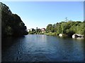
7
Houses on the west bank of the Severn
Just south of King Stephen's Mount. Seen from a narrowboat heading upstream.
Image: © Christine Johnstone
Taken: 7 Sep 2012
0.06 miles
8
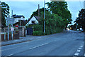
Worcester : Henwick Road A443
The A443 as it heads into the city of Worcester.
Image: © Lewis Clarke
Taken: 4 May 2014
0.08 miles
9

The far end of Worcester Racecourse
The city centre is at the other end, with the two most prominent features being the Cathedral and St Andrew's Tower.
Image: © Bill Boaden
Taken: 2 Nov 2014
0.08 miles
10
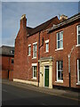
No. 218 Henwick Road, Worcester
Grade II Listed building. Eighteenth century.
Image: © Chris Allen
Taken: 16 Oct 2021
0.09 miles