IMAGES TAKEN NEAR TO
Hampton Close, WORCESTER, WR2 5LX
Introduction
This page details the photographs taken nearby to Hampton Close, WR2 5LX by members of the Geograph project.
The Geograph project started in 2005 with the aim of publishing, organising and preserving representative images for every square kilometre of Great Britain, Ireland and the Isle of Man.

There are currently over 7.5m images from over14,400 individuals and you can help contribute to the project by visiting https://www.geograph.org.uk
Image Map
Images are licensed for reuse under creativecommons.org/licenses/by-sa/2.0
Notes
- Clicking on the map will re-center to the selected point.
- The higher the marker number, the further away the image location is from the centre of the postcode.
Image Listing (29 Images Found)
Images are licensed for reuse under creativecommons.org/licenses/by-sa/2.0
Image
Details
Distance
1
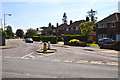
Worcester : Laugherne Road
Looking up Laugherne Road from its junction with Oldbury Road.
Image: © Lewis Clarke
Taken: 3 May 2014
0.06 miles
2
Laugherne Road, Dines Green, Worcester
Image: © Jeff Gogarty
Taken: 21 Oct 2021
0.08 miles
3
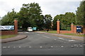
University of Worcester - entrance
Entrance from Oldbury Road to the St John's Campus.
Image: © Chris Allen
Taken: 16 Oct 2021
0.10 miles
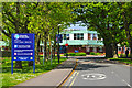
4
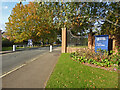
University of Worcester
The entrance to the University of Worcester. Formerly it was Worcester College of Higher Education, in the late 1990s it became University College Worcester, and in September 2005 it became the University of Worcester
Image: © Philip Halling
Taken: 15 Sep 2005
0.11 miles
5
Worcester : University of Worcester
An entrance to the university campus from Oldbury Road.
Image: © Lewis Clarke
Taken: 3 May 2014
0.11 miles
6
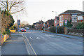
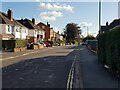
Comer Road
A mainly residential through road in Worcester. The speed limit signs reflect the fact that you are leaving a school zone.
Image: © Bill Boaden
Taken: 23 Feb 2018
0.15 miles
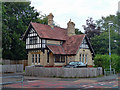
7

Worcester : The Lodge
A small house on Oldbury Road in Worcester.
Image: © Lewis Clarke
Taken: 3 May 2014
0.15 miles
8
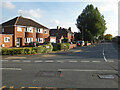
Comer Road seen from Oldbury Road, Worcester
Image: © Chris Allen
Taken: 16 Oct 2021
0.16 miles
9
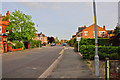
Worcester : Laugherne Road
Looking along Laugherne Road in the residential areas of Worcester.
Image: © Lewis Clarke
Taken: 3 May 2014
0.16 miles
10
Lodge, Oldbury Road, Worcester
Half-timbered, dated 1881. It served Henwick Grove which survives amid modern housing.
Image: © Stephen Richards
Taken: 17 Jul 2014
0.16 miles