IMAGES TAKEN NEAR TO
Laugherne Road, WORCESTER, WR2 5LP
Introduction
This page details the photographs taken nearby to Laugherne Road, WR2 5LP by members of the Geograph project.
The Geograph project started in 2005 with the aim of publishing, organising and preserving representative images for every square kilometre of Great Britain, Ireland and the Isle of Man.

There are currently over 7.5m images from over14,400 individuals and you can help contribute to the project by visiting https://www.geograph.org.uk
Image Map
Images are licensed for reuse under creativecommons.org/licenses/by-sa/2.0
Notes
- Clicking on the map will re-center to the selected point.
- The higher the marker number, the further away the image location is from the centre of the postcode.
Image Listing (47 Images Found)
Images are licensed for reuse under creativecommons.org/licenses/by-sa/2.0
Image
Details
Distance
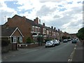
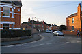
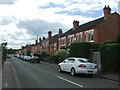
3
Worcester : Laugherne Road
Looking along Laugherne Road in the residential areas of Worcester.
Image: © Lewis Clarke
Taken: 3 May 2014
0.06 miles
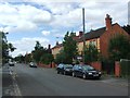
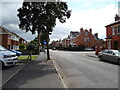
5
Laugherne Road
A mature residential part of the city.
Image: © Bill Boaden
Taken: 23 Feb 2018
0.09 miles
8
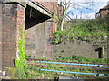
Comer Road Bridge Over Worcester to Hereford Railway Line
Image: © Roy Hughes
Taken: 22 Apr 2017
0.13 miles
9
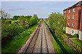
Worcester : Railway Track
The railway as seen from the bridge of Comer Road.
Image: © Lewis Clarke
Taken: 3 May 2014
0.14 miles
10
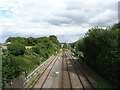
Railway into Worcester
From the bridge on Comer Road.
The line from Hereford.
Image: © JThomas
Taken: 11 Aug 2021
0.15 miles