
IMAGES TAKEN NEAR TO
Hylton Road, WORCESTER, WR2 5LA
Introduction
This page details the photographs taken nearby to Hylton Road, WR2 5LA by members of the Geograph project.
The Geograph project started in 2005 with the aim of publishing, organising and preserving representative images for every square kilometre of Great Britain, Ireland and the Isle of Man.

There are currently over 7.5m images from over14,400 individuals and you can help contribute to the project by visiting https://www.geograph.org.uk
Image Map
Images are licensed for reuse under creativecommons.org/licenses/by-sa/2.0
Notes
- Clicking on the map will re-center to the selected point.
- The higher the marker number, the further away the image location is from the centre of the postcode.
Image Listing (148 Images Found)
Images are licensed for reuse under creativecommons.org/licenses/by-sa/2.0
Image
Details
Distance
1

Crown & Anchor (1), 233 Hylton Road, Henwick, Worcester
A local public house in the Henwick suburb of Worcester. It appears in a 1910 trades directory of Worcester but is probably considerably older.
Image
Image: © P L Chadwick
Taken: 17 Jan 2015
0.02 miles
2

Crown & Anchor (2) - sign, 233 Hylton Road, Henwick, Worcester
The sign sadly is rather faded. The pub has been here for over a hundred years. The name may have been chosen as one which could be easily illustrated and easily recognisable at a time when many people could not read or write. Many pubs in Worcester had similar names. There used to be another Crown & Anchor in the city centre at 38 Silver Street but that closed a good many years ago.
Image
Image: © P L Chadwick
Taken: 17 Jan 2015
0.02 miles
3

Crown & Anchor, Worcester
A pub on Hylton Road on the way out to the north western suburbs of Worcester.
Image: © Bill Boaden
Taken: 23 Feb 2018
0.02 miles
4

Derelict public house, Hylton Road, Worcester
The Crown and anchor has clearly seen better days.
Image: © Chris Allen
Taken: 16 Oct 2021
0.02 miles
5

River Severn Mile Marker, Worcester
Seen from the river "towpath" in the rear garden of 230 Henwick Road, St John's, Worcester.
A wider view is Image
Inscription: To Stourport / 11½ / Miles
Milestone Society National ID: SEV-11½
Image: © Mr Red
Taken: 24 Aug 2023
0.04 miles
6
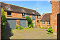
Worcester : Holywell
A house on Holywell Hill which looks to be an old farmhouse.
Image: © Lewis Clarke
Taken: 3 May 2014
0.06 miles
7
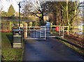
Severn Way, Henwick, Worcester
The riverside path on this bank of the Severn forms part of the Severn Way, a long distance footpath. As well as the litter bin, on the left, the red bin on the right is for dog waste.
Image: © P L Chadwick
Taken: 17 Jan 2015
0.06 miles
8
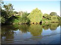
Weeping willows on the west bank of the Severn
Seen from a narrowboat heading upstream.
Image: © Christine Johnstone
Taken: 7 Sep 2012
0.06 miles
9
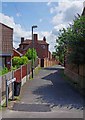
Holywell Hill, Worcester
This lane commences in Henwick Road, part of the B4206, and descends to its junction with Hylton Road, part of the A443.
Image: © P L Chadwick
Taken: 11 Jul 2015
0.06 miles
10

Weighing Room, Worcester Racecourse
The weighing room at Worcester Racecourse viewed from across the River Severn.
Image: © Philip Halling
Taken: 30 Dec 2024
0.07 miles