IMAGES TAKEN NEAR TO
Westview Close, WORCESTER, WR2 5HG
Introduction
This page details the photographs taken nearby to Westview Close, WR2 5HG by members of the Geograph project.
The Geograph project started in 2005 with the aim of publishing, organising and preserving representative images for every square kilometre of Great Britain, Ireland and the Isle of Man.

There are currently over 7.5m images from over14,400 individuals and you can help contribute to the project by visiting https://www.geograph.org.uk
Image Map
Images are licensed for reuse under creativecommons.org/licenses/by-sa/2.0
Notes
- Clicking on the map will re-center to the selected point.
- The higher the marker number, the further away the image location is from the centre of the postcode.
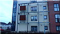
Image Listing (66 Images Found)
Images are licensed for reuse under creativecommons.org/licenses/by-sa/2.0
Image
Details
Distance
1
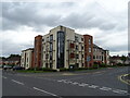
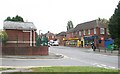
Broadway Grove, Worcester
A residential area on the outskirts of the city, near Rushwick.
Image: © Mary and Angus Hogg
Taken: 9 Jun 2008
0.12 miles
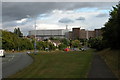
2
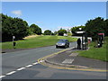
A44 at Broadway Grove
Entering the built-up area proper of Worcester with marks for the inevitable speed camera visible in the road.
Image: © Peter Whatley
Taken: 19 Jun 2008
0.13 miles
3
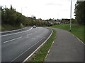
Bromyard Road into Worcester
When I last photographed this view in 2005 Image] the skyline was dominated by the large Kays distribution warehouse and offices which have since been demolished.
Image: © Philip Halling
Taken: 11 Oct 2011
0.13 miles
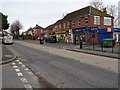
4
Shops in Broadway Grove
With the Premier newsagents and general store, next door Pete's Plaice and over the road the small building is the sewage pumping station!
Image: © Bob Embleton
Taken: 23 Sep 2007
0.13 miles
5

Drake Avenue, Dines Green
Western suburb of Worcester, dating back to the 1950's.
Image: © Jonathan Billinger
Taken: 17 Jan 2018
0.13 miles
6
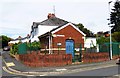
Severn Trent Water Sewage Pumping Station, Broadway Grove, Worcester
This small brick building is a sewage pumping station operated by Severn Treent Water. It is located on the corner of Broadway Grove and Grove Crescent, off Bromyard Road (part of the A44).
Image: © P L Chadwick
Taken: 29 Aug 2015
0.13 miles
7
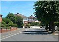
Shops on Broadway Grove
Shops, including Pete's Plaice on Broadway Grove in St John's.
Image: © Philip Halling
Taken: 14 Feb 2020
0.14 miles
8
Bromyard Road, Worcester
The large building in the background is the former Kay's distribution warehouse and offices. The Kay's operation in Worcester has since closed and these buildings gone Image]
Image: © Philip Halling
Taken: 15 Sep 2005
0.14 miles
9
This is Dines Green
Signs showing some pride in the area, a suburb of Worcester, first established in 1954.
Image: © Jonathan Billinger
Taken: 17 Jan 2018
0.14 miles