IMAGES TAKEN NEAR TO
Colletts Green, WORCESTER, WR2 4RF
Introduction
This page details the photographs taken nearby to Colletts Green, WR2 4RF by members of the Geograph project.
The Geograph project started in 2005 with the aim of publishing, organising and preserving representative images for every square kilometre of Great Britain, Ireland and the Isle of Man.

There are currently over 7.5m images from over14,400 individuals and you can help contribute to the project by visiting https://www.geograph.org.uk
Image Map
Images are licensed for reuse under creativecommons.org/licenses/by-sa/2.0
Notes
- Clicking on the map will re-center to the selected point.
- The higher the marker number, the further away the image location is from the centre of the postcode.
Image Listing (6 Images Found)
Images are licensed for reuse under creativecommons.org/licenses/by-sa/2.0
Image
Details
Distance
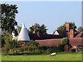
2
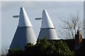
Former hop kilns
Former hop kilns converted into residential accommodation at Collett's Green Farm
Image: © Philip Halling
Taken: 10 Feb 2022
0.11 miles
3
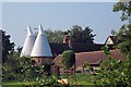
Colletts Green Farm, Powick, Collett's Green
Image: © Oast House Archive
Taken: 11 Sep 2014
0.12 miles
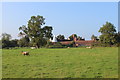
4
Colletts Green Farm, Powick, Collett's Green
Image: © Oast House Archive
Taken: 11 Sep 2014
0.12 miles
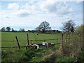
5
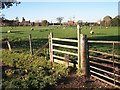
Bank Farm, Daws Hill
Viewed from the east along the footpath from Kings End.
Image: © Bob Embleton
Taken: 17 Nov 2005
0.12 miles