IMAGES TAKEN NEAR TO
Hanbury Park Road, WORCESTER, WR2 4PH
Introduction
This page details the photographs taken nearby to Hanbury Park Road, WR2 4PH by members of the Geograph project.
The Geograph project started in 2005 with the aim of publishing, organising and preserving representative images for every square kilometre of Great Britain, Ireland and the Isle of Man.

There are currently over 7.5m images from over14,400 individuals and you can help contribute to the project by visiting https://www.geograph.org.uk
Image Map
Images are licensed for reuse under creativecommons.org/licenses/by-sa/2.0
Notes
- Clicking on the map will re-center to the selected point.
- The higher the marker number, the further away the image location is from the centre of the postcode.
Image Listing (20 Images Found)
Images are licensed for reuse under creativecommons.org/licenses/by-sa/2.0
Image
Details
Distance
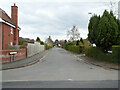
1
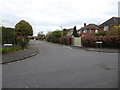
Croome Road from Hill View Road, Lower Wick
A residential area composed of sizable houses that appear to be mid-20th century. One of the nicer parts of Worcester to walk around.
Image: © Chris Allen
Taken: 27 Mar 2021
0.03 miles
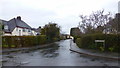
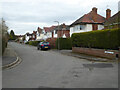
2
Junction of Hanbury Park Road and Hill View Road
A residential area composed of sizable houses that appear to be mid-20th century. Hanbury Park Road is to the left and Hill View Road is on the right.
Image: © Chris Allen
Taken: 27 Mar 2021
0.03 miles
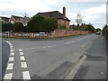
3
Hanbury Park Road, Worcester
Leafy suburbs in the south-west of the city.
Image: © Jonathan Billinger
Taken: 14 Feb 2018
0.04 miles
4
Swinton Lane from Hanbury Park Road
A public footpath leads off from the apex of the curve on the left. I decided this was too narrow and busy to traverse in this time of Covid-19 so went the long way round.
Image: © Chris Allen
Taken: 27 Mar 2021
0.05 miles
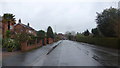
5
Earlsdon Road, Worcester
Leafy suburbs in the south-west of the city.
Image: © Jonathan Billinger
Taken: 14 Feb 2018
0.07 miles
6
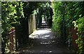
Footpath, Hanbury Park, Worcester.
The footpath runs alongside the park (now a golf course) from Hanbury Park Road.
Image: © Bob Embleton
Taken: 12 Aug 2007
0.10 miles
7
Chamberlain Road from Hanbury Park Road, Worcester
Image: © Chris Allen
Taken: 27 Mar 2021
0.11 miles
8
Junction of Chamberlain road and Croome Road, Lower Wick
Chamberlain Road is straight ahead and Croome Road is to the right.
Image: © Chris Allen
Taken: 27 Mar 2021
0.13 miles
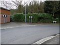
9

Manor Road from Hanbury Park Road, Worcester
A mature, leafy suburb.
Image: © Chris Allen
Taken: 27 Mar 2021
0.14 miles
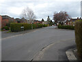
10
Stanmore Road, Lower Wick, Worcester
A residential area characterised by larger 20th century houses.
Image: © Chris Allen
Taken: 27 Mar 2021
0.16 miles