IMAGES TAKEN NEAR TO
Trelawney Close, WORCESTER, WR2 4HG
Introduction
This page details the photographs taken nearby to Trelawney Close, WR2 4HG by members of the Geograph project.
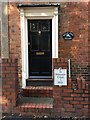
The Geograph project started in 2005 with the aim of publishing, organising and preserving representative images for every square kilometre of Great Britain, Ireland and the Isle of Man.

There are currently over 7.5m images from over14,400 individuals and you can help contribute to the project by visiting https://www.geograph.org.uk
Image Map
Images are licensed for reuse under creativecommons.org/licenses/by-sa/2.0
Notes
- Clicking on the map will re-center to the selected point.
- The higher the marker number, the further away the image location is from the centre of the postcode.
Image Listing (184 Images Found)
Images are licensed for reuse under creativecommons.org/licenses/by-sa/2.0
Image
Details
Distance
1
Replica Mileplate, B4485, Bransford Road, Worcester
The mileplate is attached to the gate brick pillar of Mile End House, on the north side of the road, between Blakefield Road and School Road. One of six replica mileplates installed by the Worcester Group of the Milestone Society in 2018; original milestones were by Worcester Turnpike Trust.
Inscription reads:-
To / Worcester / Cross / 1 Mile
Milestone Society National ID: WO_WOMV01R
Image: © Jan Scrine
Taken: 6 Oct 2019
0.03 miles
2
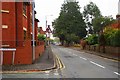
Bransford Road, St. John's, Worcester
A mainly residential road, photographed from the junction with Blakefield Road. There is a bus stop on the right-hand side of Bransford Road.
Image: © P L Chadwick
Taken: 2 Nov 2015
0.05 miles
3
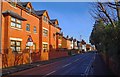
Apartments in Bransford Road, St. John's, Worcester
Modern apartments in the popular suburb of St. John's.
Image: © P L Chadwick
Taken: 24 Jan 2015
0.05 miles
4
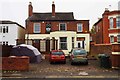
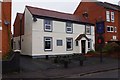
Herefordshire House (1), 99 Bransford Road, St. John's, Worcester
This public house, which in recent years was a free house, appears to have closed around April 2014. Since then some of the signage has been removed - there used to be a large name sign above the bay window at the front. When it was open it had two bars and a skittles alley. It normally kept M & B Brew XI on tap and a guest beer. It seems at present to be in use as residential accommodation.
Image
In an earlier photograph from January 2015,it can be seen that the pub's name also used to be above the entrance door on the right. Image
Image: © P L Chadwick
Taken: 2 Nov 2015
0.06 miles
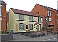
5
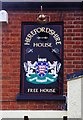
Herefordshire House (2) - sign, 99 Bransford Road, St. John's, Worcester
Although this public house appears to have closed around April 2014 this sign currently remains at first floor level. There also used to be a much larger name sign above the bay window. Why Worcestershire pubs should be named after the County of Herefordshire is a bit of a mystery to me, but there is still a pub of the same name at Stanford Bishop near Worcester. There was also at one time another in the city of Worcester in Newport Street. Maybe there were others.
Image
Image: © P L Chadwick
Taken: 2 Nov 2015
0.06 miles
6
The Crown (1), 66 Bransford Road, St. John's, Worcester
The Crown, formerly the Crown Inn, re-opened and promotes itself as the "rugby pub".
Image
Image: © P L Chadwick
Taken: 26 Nov 2014
0.06 miles
7
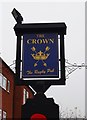
The Crown (2) - sign, 66 Bransford Road, St. John's, Worcester
Now known as the Crown rather than the Crown Inn, and promoting itself as the rugby pub.
The Crown indicates loyalty to the reigning monarch. It has been used as an inn or pub sign for hundreds of years. In the past, when most people were illiterate, the sign was easily recognised by people. The Crown is almost as popular as the Red Lion as a pub name.
The pub's sign in 2010 is shown here:- Image
Image
Image: © P L Chadwick
Taken: 26 Nov 2014
0.06 miles
8
St John's Rugby Pub, The Crown
St John's Rugby Pub, The Crown, on Bransford Road in St John's, Worcester.
Image: © Philip Halling
Taken: 10 Dec 2015
0.06 miles
9

Herefordshire House (January 2015), 99 Bransford Road, St. John's, Worcester
At the time this photo was taken in January 2015, the pub had been closed several months and already the large name sign above the bay window had been removed. Later this area was repainted. Above the entrance door on the right the pub's name still remained but this had been removed by the time I re-photographed it in November 2015. Unfortunately the January photo does suffer from having been taken directly into the sun but I feel it is of interest because of the subsequent changes.
November 2015 photograph:- Image
Image: © P L Chadwick
Taken: 24 Jan 2015
0.07 miles
10
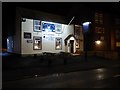
Crown Inn (closed) (1), 66 Bransford Road, St. John's, Worcester
It's sad to see yet another pub which has closed, and perhaps surprising in this area, as it has a large student population. At the beginning of July 2010, the pub was on the market for £225,000. Update - the pub re-opened and is known as the Crown rather than the Crown Inn.
Image
Image
Photographed in November 2014:- Image
Image: © P L Chadwick
Taken: 1 Aug 2010
0.07 miles