IMAGES TAKEN NEAR TO
St. Michaels, TENBURY WELLS, WR15 8TW
Introduction
This page details the photographs taken nearby to WR15 8TW by members of the Geograph project.
The Geograph project started in 2005 with the aim of publishing, organising and preserving representative images for every square kilometre of Great Britain, Ireland and the Isle of Man.

There are currently over 7.5m images from over14,400 individuals and you can help contribute to the project by visiting https://www.geograph.org.uk
Image Map (Loading...)


Getting Data...Please wait
Leaflet Map data © OpenStreetMap
Images are licensed for reuse under creativecommons.org/licenses/by-sa/2.0
Notes
- Clicking on the map will re-center to the selected point.
- The higher the marker number, the further away the image location is from the centre of the postcode.
Image Listing (8 Images Found)
Images are licensed for reuse under creativecommons.org/licenses/by-sa/2.0
Image
Details
Distance
1
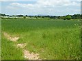
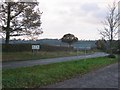
Farmland on the Herefordshire Worcestershire border
Farmland on the Herefordshire Worcestershire border near St Michaels. St Michaels Caravan Park can be seen beyond the hedge, and in the distance Titterstone Clee Hill in Shropshire can be seen.
Image: © Philip Halling
Taken: 25 May 2017
0.09 miles
2
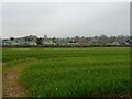
Cereal crop towards St Michaels Caravan Park
Image: © JThomas
Taken: 17 Apr 2023
0.11 miles
3
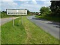
The A4112 entering Worcestershire
The A4112 from Leominster to Tenbury Wells entering Worcestershire near St Michaels. The outline of the county of Worcestershire resembles that of France with the north-west part of the county projecting to the west into Herefordshire and Shropshire rather like Brittany into the Atlantic Ocean.
Image: © Philip Halling
Taken: 25 May 2017
0.14 miles
5
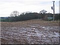
Harvested maize, Gorsty
Muddy field which was used to grow maize for winter feed. Westward view from just inside Herefordshire.
Image: © Richard Webb
Taken: 6 Dec 2005
0.14 miles


8
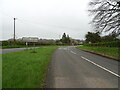
A bitter dispute.
A welcome return of a roadsign in the 1990s, after the rather unpopular expansion of Worcestershire westward in 1974. Like Rutland Herefordshire was swallowed up by a more populated neighbour, only here Worcester closed the place down like a hostile merger. On regaining independence in 1997, the return of the regalia, and county hall furniture became an issue - Worcestershire had sold it. No love lost across this line. (They also tried to sell a portrait of Stanley Baldwyn, Prime Minister and Worcestershire MP - only at the last minute the Baldwyn family who had loaned the painting found out and retrieved their property.)
View South towards the infamous Raddle Bank, a steep climb on to the plateau to Leysters.
Image: © Richard Webb
Taken: 6 Dec 2005
0.19 miles