IMAGES TAKEN NEAR TO
Kyrewood, TENBURY WELLS, WR15 8SG
Introduction
This page details the photographs taken nearby to WR15 8SG by members of the Geograph project.
The Geograph project started in 2005 with the aim of publishing, organising and preserving representative images for every square kilometre of Great Britain, Ireland and the Isle of Man.

There are currently over 7.5m images from over14,400 individuals and you can help contribute to the project by visiting https://www.geograph.org.uk
Image Map (Loading...)


Getting Data...Please wait
Leaflet Map data © OpenStreetMap
Images are licensed for reuse under creativecommons.org/licenses/by-sa/2.0
Notes
- Clicking on the map will re-center to the selected point.
- The higher the marker number, the further away the image location is from the centre of the postcode.
Image Listing (9 Images Found)
Images are licensed for reuse under creativecommons.org/licenses/by-sa/2.0
Image
Details
Distance
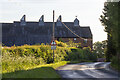
3
The Hop Kilns, Kyrewood
Built in the miniature style of oast house kilns.
Image: © Oast House Archive
Taken: 12 Sep 2014
0.05 miles
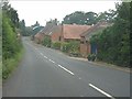
5
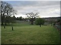
A tidy field
A view across a mown field from the junction of a couple of footpaths. It was horribly wet and muddy underfoot during a prolonged wet spell. There are several newly planted orchards nearby, one in the distance.
Image: © Richard Webb
Taken: 25 Dec 2012
0.08 miles
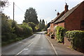
7

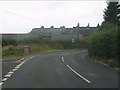
No through road at Kyrewood
No through road off the B4204 at Kyrewood.
Image: © Philip Halling
Taken: 18 Jul 2015
0.13 miles
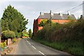
8
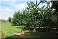
Apple orchard
Apple orchard opposite Kyrewood House.
Image: © Philip Halling
Taken: 18 Jul 2015
0.15 miles
9
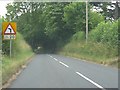
B4204 dropping towards Tenbury Wells
The final mile into Tenbury features both a steep gradient and several very tight bends.
Image: © Peter Whatley
Taken: 23 Jul 2013
0.22 miles