IMAGES TAKEN NEAR TO
Sutton, TENBURY WELLS, WR15 8RN
Introduction
This page details the photographs taken nearby to WR15 8RN by members of the Geograph project.
The Geograph project started in 2005 with the aim of publishing, organising and preserving representative images for every square kilometre of Great Britain, Ireland and the Isle of Man.

There are currently over 7.5m images from over14,400 individuals and you can help contribute to the project by visiting https://www.geograph.org.uk
Image Map
Images are licensed for reuse under creativecommons.org/licenses/by-sa/2.0
Notes
- Clicking on the map will re-center to the selected point.
- The higher the marker number, the further away the image location is from the centre of the postcode.
Image Listing (11 Images Found)
Images are licensed for reuse under creativecommons.org/licenses/by-sa/2.0
Image
Details
Distance
1
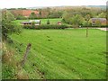
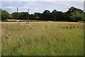
Nineveh
Hamlet on the Tenbury - Bromyard road. View over pasture from the Honeycombe Farm road.
Image: © Richard Webb
Taken: 1 May 2010
0.04 miles
2
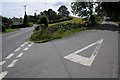
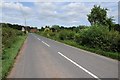
Road junction on the B4214
The road to the right is a no through road giving access to Honeycombe Farm.
Image: © Philip Halling
Taken: 18 Jul 2015
0.05 miles
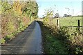
3
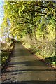
Autumn trees on Vine Lane
Autumn trees on Vine Lane, a no through road providing access to Honeycombe Farm near Kyre.
Image: © Philip Halling
Taken: 22 Nov 2022
0.05 miles
4
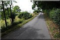
No through road
No through road to Honeycombe Farm near Kyre.
Image: © Philip Halling
Taken: 18 Jul 2015
0.05 miles
5
A hay field awaiting harvest
There appears to be a good crop of grass in these fields near Kyre. A footpath crosses this field, at present the long grass would impede progress.
Image: © Philip Halling
Taken: 18 Jul 2015
0.10 miles
6
The B4214 north of Kyre
The B4214 between Bromyard and Tenbury Wells pictured here near Nineveh, north of Kyre.
Image: © Philip Halling
Taken: 18 Jul 2015
0.11 miles
7
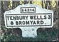
Old Milestone by the B4214, Kyre parish
Metal plate attached to concrete post by the B4214, in parish of Kyre (Malvern Hills District), North of Nineveh; across road 15 yds from cottage, in hedge, on West side of road. Bradley post, erected by the County Council in the 20th century.
Inscription reads:-
B4214
TENBURY 3
8 BROMYARD.
C.C.W.
Milestone Society National ID: WO_TBBY03
Image: © J Higgins
Taken: 1 Apr 2007
0.16 miles
8
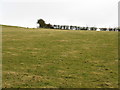
Grazing Land Near Nineveh
A few sheep are visible near the skyline.
Image: © Peter Whatley
Taken: 10 Feb 2010
0.19 miles
9
Vine Lane
Vine Lane, a no through road near Kyre.
Image: © Philip Halling
Taken: 22 Nov 2022
0.21 miles
10
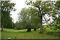
Kyre/Sutton Parish Boundary
The small stream running along the fenceline is not named on the OS maps, but determines the boundary between the two parishes. After a few hundred metres (behind the camera) it joins the Kyre Brook which in turn joins the River Teme at Tenbury.
Image: © Bob Embleton
Taken: 3 Jun 2007
0.22 miles