IMAGES TAKEN NEAR TO
Stoke Bliss, TENBURY WELLS, WR15 8RF
Introduction
This page details the photographs taken nearby to WR15 8RF by members of the Geograph project.
The Geograph project started in 2005 with the aim of publishing, organising and preserving representative images for every square kilometre of Great Britain, Ireland and the Isle of Man.

There are currently over 7.5m images from over14,400 individuals and you can help contribute to the project by visiting https://www.geograph.org.uk
Image Map (Loading...)


Getting Data...Please wait
Leaflet Map data © OpenStreetMap
Images are licensed for reuse under creativecommons.org/licenses/by-sa/2.0
Notes
- Clicking on the map will re-center to the selected point.
- The higher the marker number, the further away the image location is from the centre of the postcode.
Image Listing (12 Images Found)
Images are licensed for reuse under creativecommons.org/licenses/by-sa/2.0
Image
Details
Distance
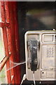
1
Telephone box, Bank Street
Telephone box beside the B4214 at Bank Street.
Image: © Philip Halling
Taken: 30 Nov 2013
0.03 miles
3
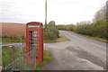
Telephone box, Stoke Bliss
Under notice of removal.
Image: © Richard Webb
Taken: 8 Oct 2017
0.06 miles
4
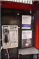
Dim arian, dim problem, dim ff?n
Bilingual notice in doomed Worcestershire telephone box.
Image: © Richard Webb
Taken: 8 Oct 2017
0.06 miles
5
Telephone box, Stoke Bliss
Not been used for a while and probably disconnected. A notice in English and Welsh states that it is to be removed.
Image: © Richard Webb
Taken: 8 Oct 2017
0.06 miles
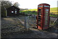
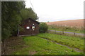
6
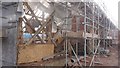
Barn restoration
Conversion, Stoke Bliss
Image: © Richard Webb
Taken: 8 Oct 2017
0.15 miles
7
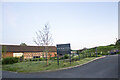
Penson's Farm
Converted Farm Building at Penson's Farm
Image: © P Gaskell
Taken: Unknown
0.16 miles
8

Barn conversion
Barn undergoing conversion at Penson's near Kyre.
Image: © Philip Halling
Taken: 30 Nov 2013
0.16 miles
9
French-style Milestone On The B4214
A very solid item in concrete with metal detail plates.
Image: © Peter Whatley
Taken: 10 Feb 2010
0.22 miles
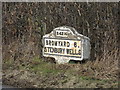
10
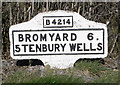
Old Milestone by the B4214, Bank Street, Stoke Bliss parish
Metal plate attached to concrete post by the B4214, in parish of STOKE BLISS (MALVERN HILLS District), Bank Street, in hedge, on East side of road. Bradley post, erected by the County Council in the 20th century.
Inscription reads:-
B4214
BROMYARD 6.
5 TENBURY WELLS
C.C.W.
Carved benchmark and rivet on top.
Milestone Society National ID: WO_TBBY05.
Image: © J Higgins
Taken: 1 Apr 2007
0.22 miles