IMAGES TAKEN NEAR TO
Boraston Lane, TENBURY WELLS, WR15 8RB
Introduction
This page details the photographs taken nearby to Boraston Lane, WR15 8RB by members of the Geograph project.
The Geograph project started in 2005 with the aim of publishing, organising and preserving representative images for every square kilometre of Great Britain, Ireland and the Isle of Man.

There are currently over 7.5m images from over14,400 individuals and you can help contribute to the project by visiting https://www.geograph.org.uk
Image Map (Loading...)


Getting Data...Please wait
Leaflet Map data © OpenStreetMap
Images are licensed for reuse under creativecommons.org/licenses/by-sa/2.0
Notes
- Clicking on the map will re-center to the selected point.
- The higher the marker number, the further away the image location is from the centre of the postcode.
Image Listing (19 Images Found)
Images are licensed for reuse under creativecommons.org/licenses/by-sa/2.0
Image
Details
Distance
1
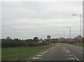
Housing at Burford
New housing at Burford viewed from the road from Boraston.
Image: © Philip Halling
Taken: 30 Jul 2011
0.09 miles
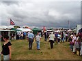
2
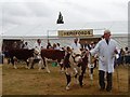
National Hereford Show
Heifers (c. 1yr old) in the judging ring. This young lady has appeared before on the site and did not do too well, but was up to the high standard here - the traditional low bodied style of Hereford is very out of fashion - and she was too well fed!
Image: © Richard Webb
Taken: 5 Aug 2006
0.11 miles
3
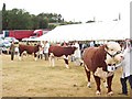
Here comes the judge
Bulls being judged. The judge is a Texas rancher. Unlike the usual practice, he commented on his judgement and gave an appraisal of each animal.
National Hereford Show - Tenbury 2006.
Image: © Richard Webb
Taken: 5 Aug 2006
0.12 miles
4
National Hereford Show
Show within a show - a major showpiece for Hereford cattle. Started as a response to the popularity of the polled , naturally hornless, breed in the 1970's . Held within Tenbury Show, a long established show, but other than the Herefords rather short on livestock.
Behind the bulls is a line of trees marking the old railway from Woofferton to Kidderminster.
Image: © Richard Webb
Taken: 5 Aug 2006
0.12 miles
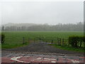
6
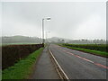
Farmland at Spurtree
Farmland between Spurtree and Burford to the north of Tenbury Wells. The hedgerow on the right marks the line of a disused railway line.
The line used to link Worcester with Leominster via Bromyard. This was a comparatively short lived railway line. Parliament agreed its building in August 1861, but its construction was slow and it took until 1897 for the whole line to be completed. With the increased usage of motor vehicles and growing car ownership it was doomed with the section between Bromyard and Leominster closing on 15 September 1952. This stretch of line was then used some six years to store around 600 condemned wagons. The last recorded train between Leominster and Bromyard ran on 26 April 1958, hauled by an ex-GWR class 45XX 2-6-2T no 4571 - six years after closure! The Bromyard to Worcester section of the line didn't survive Dr Beeching and was last used between Bromyard and the Bransford Road junction section on September 7 1964. Source: Leslie Oppitz
on the BBC Hereford and Worcester website.
Image: © Philip Halling
Taken: 30 Jul 2011
0.20 miles
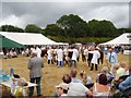
7
Tenbury Show
The trade stands, beside the A456 across the main ring from the livestock.
Image: © Richard Webb
Taken: 5 Aug 2006
0.20 miles
9
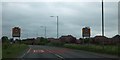
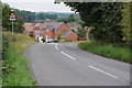
First sight of Burford from the east
The edge of the housing in the village is defined by a modern estate
Image: © David Smith
Taken: 20 May 2013
0.20 miles